THE MANOR, TITHING & BARTON OF MERTHEN

TheBarton of Merthenhas belonged to the Vyvyans ofTrelowarrenfor three hundred years.

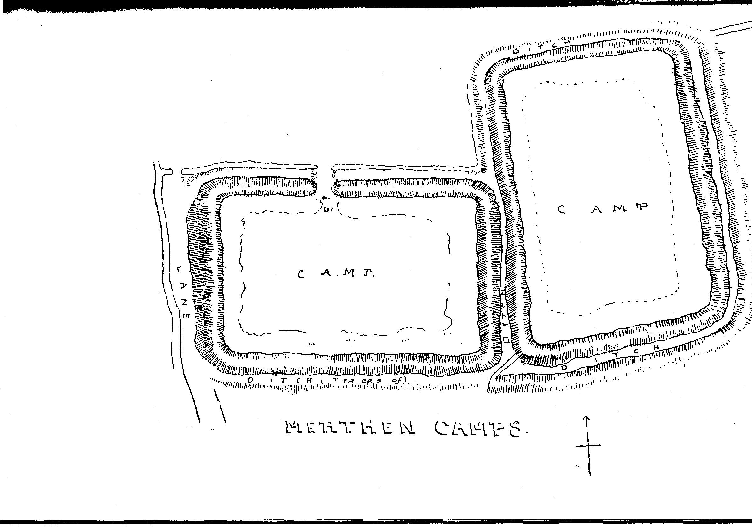
It occupies a promontory that runs out into a long tail-like point, known as theGroyne,between the two principal arms of theHelford River. From theBartonHouse, and still more fromthe ancient earthworks 350 yards northwestof it, one obtains a view that commands the mouth of the Haven , and it is easy to understand why the Lords of Merthen have always had such extensive rights over the river. The meaning of the name Merthen is obscure. It has, however, nothing whatever to do with the place-name Merther implying a Chapel in honour of a martyr. The earliest spelling of the name, Meredin, suggests that it is called after a Din or fortress, and the remarkable earthworks in the old Deer-park bear this out. These earthworks (which have been described on p. 13) consist of two rectangular enclosures, each of about one acre in area, which join each other at right angles. The site which they occupy is more commanding than the site of the farm house, and the line of a very ancient ridgewaycoming fromMerthen Quaynorthwards passes through the western ditch of one of them. There are places called Merthen in St. Austell and Buryan. Both lie on the coast, the former on a long promontory not unlike the Groyne, though the creek on one side of it has been filled up.The wordDin, a fortress, latinized intoDunum, was used for a chief’s residence or capital town. Moridunum (i.e. the sea-city) is named in the Roman Itineraries as a port on the Roman road east of Exeter and is generally identified with Sidmouth. Merthen, the Meridin of the 12th century, may well have been another Moridunum, a fortress embraced by arms of the sea, which afforded a haven protected from storms and hostile attack. Although Merthen has been a farm on the Trelowarren estate for just three centuries, it has usually been occupied by well-to-do tenants such as members of the Vyvyan family itself, the Tyackes etc. and it has preserved much of its former dignity. In the Middle Ages,


ANCIENT ROADS AND TRACKS.

The road system of Constantine is not merely medieval, it is prehistoric. This is not intended to be a criticism of those who have charge of the roads but merely a statement of fact. There are no

roads in the parish worth mentioning that have been made in modern

times1.W e have seen that the principal roads leading northwards from the Helford River are ridgeways. The most westerly is still in use as the main road from Gweek to the Helston-Truro road (itself a ridgeway) at Buttres Gate. Beyond that it once continued by Stythians, Bissoe and

Baidu till it joined the principal ridgeway running along the watershed

from one end of Cornwall to the other. This road brought the tin

bearing region of Stythians into communication with the port of Gweek.

It enters Constantine parish at a place called Ponstreath or Ponstrays,

which is possibly a corruption of Penstrase, i.e., Street-end, the word strase or strad being used for a paved way, a relic of the Roman strata.A t Carloggas a fortification adjoined it. At Tolvan it was crossed by

the principal track leading across the parish, and the meeting place of the roads was doubtless suggested by the presence of the Tolvan

Quoit2.

The second ridgeway from Gweek runs up to Carwythenack Chase, where an earthwork lies on its left hand3. Then it went straight up over the top of Brill hill, to Trevease, passing the stone cross at the ford, and so out to join the other ridgeway at Buttres Gate. This road is only used in its lower part, but it can be traced through the crofts on Brill hill by a double line of hedges.


Ancient Roads and Tracks 17

The third ancient ridgeway is that coming from the Quay at Merthen Hole4, up through the woods, across the old deer park, where it passes through the ditch of the earthworks, so out over the Downs, across the fields to Brill. Then to Trewardreva and over the ford (Ret) which gave name to Retallack. So up the hill along past the site of Maen Rock, skirting Treworvac, across the fields to the “ Dead lane” , where it proves its antiquity by being a part of the parish boundary, then into the Lestraines lane and out to the Turnpike from Helston to Truro at Rame. The “ Dead lane ” is a strip of this ridgeway which has not been used for over a century, and is so called because It is now a cul-de-sac. On either side of it is a tumulus, for barrows, like ancient roads, are found on ridges. It is remarkable that this lane, about three-quarters of a mile in length, is the only piece of road which forms part of the Constantine parish boundary. All the rest of the boundary is formed by creeks, streams, or, for a very small distance, by hedges. At Merthen Hole it is a typical pack-horse track cut out of the rock. Its paving stones remain beneath the fields and make ploughing Impossible.The fourth main ridgeway is the present main road from Penryn, entering the parish near Bossawsack and continuing past High Cross down to the river atCalamansack. There are two principal tracks across the parish from east to west, 2nd as the lower has to traverse six deep valleys, it affords a good example of the precipitous nature of old roads.

This enters the parish from Mawnan at Tregarne Mill, passes the steep hill to Treworval , by what is now a rough lane, continues across the fields to Driff and Treviades, then down past Gwealllin to the creek-head at Polwheveral. This part bore the name Clodgy lane in 1649, a common name in Cornwall, derived, in all zbability, from Clud, a carriage, or perhaps from Clodding, meaning trenched ” or “ embanked5.” At the bottom stood two grist mills, d • Tucking or Fulling Mill. The bridge over the stream was built «57*> as appears from the contract between the parish and Roger Urd, a mason, of Tregoney, entered into the old Vestry Book6. Thla (ipp ears to continue on the other side of the river through Tremayne and Henforth ( = Old road) to St. Martins.‘,f. C lodgy lane at Helston. [M r. Henderson later changed his mind, and Came to the conclusion that Clodgy meant a Lazar-house. G .H .D .] a copy of this interesting document in the present writer’s Old Cornish Bridges,

One of the intriguing aspects of Britains history is the potential Roman origins of Bartons, a key location for trade through waterways. The geographical significance of Bartons suggests its vital role in facilitating commerce during ancient times. Exploring the remnants of this historical trading hub allows historians to delve deeper into Devon's past and understand its cultural and economic importance.

The origins of Barton and its association with Roman trade routes continue to inspire historical research and speculation. The abundant waterways in the region provided an ideal environment for commerce and played a vital role in connecting different areas. Historians can uncover the remnants of this ancient trading network in Bartons, gaining valuable insights into the economic activities and cultural exchange that took place in Devon centuries ago. By examining the geographical features and historical artifacts, historians can piece together the story of Bartons' significant contribution to Devon's past and the broader context of Roman trade in the region.barton
Collins English Dictionary. Copyright © HarperCollins PublishersWord origin Old English beretūn, from bere barley + tūn stockade; see town but I have my own ideas, firstly and probably incorrectly that the ton on the end is saxon, is it , then what is the bar and why is it , so common ,that these Bartons relate , at least lets say they are old fashioned in terms of E culture 2021 ,some mention of priories under invesgation of roman port @ merthen

Trethowan
123
the estate was held in undivided moieties by Christopher Walker (J) Richard Gerveys (J) John Thom’s (|). It was afterwards purchased
entirely by the Trefusis family and added to their manor of Treworval.
In 1842 Lord Clinton was the owner.
Some stone archways are all that remain of the Elizabethan
mansion of the Penticosts.
TRETHOWAN.
Trethowan (120 acres) gave name and origin to a family of small gentry, resident here in the 16th and 17th centuries. The name Trethowan is still found in the parish. Alan Trethouen paid the subsidy in 1327. Henry Trethowyn did homage to the Lord of Merthen for a Cornish acre held in Trethowyn in Knight’s service. In
1528 part of Trethowyn was held by the heirs of Trethowyn and part,
with Polpry, by Gerveys of Bonallack, both under the Manor of
Merthen in Knight’s service. John Trethowan of Trethowan married,
in 1582, Avis, daughter of Thomas Enys of Enys by Katherine
Reskymer of Merthen. In 1649 and 1660 Thomas Trethowan was
living at Trethowan, which was his freehold. In 1726 John Trethowan
owned it.3
After that the family appears to have sold its land to the Vyvyans
of Trelowarren. C. S. Gilbert (<Survey of Cornwall II, 184) in 1820
noticed “ a shield over the entrance of the house which is supposed to
bear the Arms of Trethowan, apparently three garbs.” Trethowan
farm house is in ruins and shows no traces of ancient work except
some granite quoins. The shield has disappeared. Trethowan is now
farmed with Merthen.
There is said to be a crock of gold buried at Trethowan , and more
than one vain attempt has been made to discover it.
3 John Trethowan, gent., married Sarah Winn at Constantine on Nov. 18,

Constantine of Dumnoniaˈkɒnstənt,Welsh:Cystennin, 520–523 was a 6th-century king ofDumnoniainsub-Roman Britain, who was remembered in laterBritish traditionas alegendary King of Britain. The only contemporary information about him comes fromGildas, who castigated him for various sins, including the murder of two "royal youths" inside a church. The historical Constantine is also known from the genealogies of the Dumnonian kings, and possibly inspired the tradition ofSaint Constantine, a king-turned-monk venerated in Southwest Britain and elsewhere.

In the 12th century , Geoffrey of Monmouth included Constantine in his pseudohistorical chronicle Historia Regum Britanniae , adding details to Gildas' account and making Constantine the successor to King Arthur as King of Britain . Under Geoffrey's influence , Constantine appeared as Arthur's heir in later chronicles . Less commonly , he also appeared in that role in medieval Arthurian romances and prose works , and in some modern versions of the legend.

HistorySouthern Britain in c. 540, the time of Gildas . Constantine's likely kingdom of Dumnonia is in the southwest; the territory of the Damnonii is in the northwest.

The 6th-century monk Gildas mentions Constantine in chapters 28 and 29 of work De Excidio et Conquestu Britanniae . Constantine is one of five Brittonickings whom the author rebukes and compares to Biblical beasts. Gildas calls Constantine the "tyrannical whelp of the unclean lioness of Damnonia", a reference to the books of DanielandRevelation, and apparently also a slur directed at his mother. ThisDamnoniais generally identified as the kingdom of DumnoniainSouthwestern Britain.[2]Scholars such asLloyd LaingandLeslie Alcocknote the possibility that Gildas may have instead intended the territory of theDamnonii, a tribe in present-dayScotlandmentioned byPtolemyin the 2nd century, but others such as Thomas D. O'Sullivan consider this unlikely.[3]

Gildas says that despite swearing an oath against deceit and tyranny, Constantine disguised himself in anabbot's robes and attacked two "royal youths" praying before a church altar, killing them and their companions. Gildas is clear that Constantine's sins were manifold even before this, as he had committed "many adulteries" after casting off his lawfully wedded wife. Gildas encourages Constantine, whom he knows to still be alive at the time, to repent his sins lest he be damned.[1]The murders may relate to a 6th-century cult inBrittanyhonoring theSaints Dredenau, two young princes killed by an ambitious uncle.[4]

Scholars generally identify Gildas' Constantine with the figureCustennin GorneuorCustennin Corneu(Constantine of Cornwall) who appears in the genealogies of the kings of Dumnonia.[5]Custennin is mentioned as the father ofErbinand the grandfather of the heroGeraintin theBonedd y Saint, the prose romanceGeraint and Enid, and after emendation, thegenealogies in Jesus College MS 20.[6][7]Based on Custennin's placement in the genealogies, Thomas D. O'Sullivan suggests afloruitfor Constantine of 520–523.[8]

Saint Constantine .

Constantine (British saint)

Saint Constantine's Church in Constantine , Cornwall , perhaps connected to the historical king of Dumnonia . The historical Constantine of Dumnonia may have influenced later traditions, known in Southwestern Britain as well as in Wales , Ireland , and Scotland , about a Saint Constantine who is usually said to have been a king who gave up his crown to become a monk . The Cornish and Welsh traditions especially may have been influenced by Gildas , in particular his adjuration for Constantine to repent ; the belief may have been that the reproach eventually worked.

The two major centers for the cultus of Saint Constantine were the church in Constantine Parish and the Chapel of Saint Constantine in St Merryn Parish , nowConstantine Bay , both in Cornwall . The former was established by at least the 11th century, as it is mentioned in Rhygyfarch's 11th-century Life of Saint David . At this time it may have supported a clerical community , but in later centuries it was simply a parish church . The Chapel at Constantine Bay had a holy well , and was the center of its own sub-parish .The Annales Cambriae Welsh Annals) and the Annals of Ulster record the conversion of a certain Constantine; these may be a reference to the Cornish saint and therefore to the historical figure. Several subsequent religious texts refer to Constantine, generally associating him with Cornwall, often specifically as its king. TheLife of Saint Davidsays that Constantine, King of Cornwall, gave up his crown and joinedSaint David's monastery atMenevia. TheVitae Petrociincludes an episode in whichSaint Petrocprotects a stag being hunted by a wealthy man named Constantine, who eventually converts and becomes a monk. Here Constantine is not said to be king, but a 12th-century text referring to this story, theMiracula, specifically names him as such, further adding that upon his conversion he gave Petroc an ivory horn that became one of the saint's chief relics.[10]A number of other traditions attested across Britain describe saints or kings named Constantine, suggesting a confusion and conflation of various figures.[11]

Other sites in Southwestern Britain associated with figures named Constantine include the church ofMilton Abbot, Devon; a chapel in nearbyDunterton, Devon; and a chapel inIllogan, Cornwall. The two Devon sites may have been dedicated instead toConstantine the Great, as local churches were subject toTavistock Abbey, dedicated to Constantine the Great's mother Helena. In Wales, two churches were dedicated to Constantine : Llangystennin ( inConwy ) and Welsh Bicknor (now inHerefordshire , England).The church in Govan , a parish in present-day Scotland, was also dedicated to a Saint Constantine.

The Tolvan Stone - Historical landmark

Tolvan hole

    Coordinates:50.105121°N 5.209012°W

    From Wikipedia, the free encyclopedia

    Tolvan holed stone

    Tolvan holed stone


    Shown within Cornwall

    RegionCornwallCoordinates50.105121°N 5.209012°WTypeHoled stone

    Scheduled monument

    Official nameTolvan Holed stoneDesignated1923[1]Referenceno.427073[2]

    TheTolvan holed stoneis a triangular-shapedNeolithicstanding stone. The monument is 2.3m high and consists of a circular hole near its base measuring 43cm in diameter. Themegalithicstone is located in the garden of Tolvan Cross Cottage, near the village ofGweekinCornwall,England. The holed stone is the largest of its kind in Cornwall.

    Description[edit]

    The Tolvan holed stone is a large triangular-shaped standing stone. It measures 2.3m high, 2.3m wide at the base, and is 0.3m thick. Near the base of the monument is a circular hole, approximately 43cm in diameter.[3]The standing stone is located about 800m north of the village ofGweekin Cornwall, England, behind the farmhouse at Tolvan Cross. The megalith is not in its original location, but was moved to its current position in 1847 A cottage was later built at the site.[1]The Tolvan stone is the largest holed stone in Cornwall.[2]

    History[edit]

    Holed stones are rare Neolithic monuments. It has been suggested that the large standing stones were part of megalithic structures, used as entrance passages to the burial chambers ofportal dolmens. These standing stones are believed to have been constructed in the Early and Middle Neolithic period (3500 - 2600 BC). At least 20 portal dolmens exist in Britain, and the majority of these burial monuments are found in west Cornwall.[1]

    "Tolvan" originated from the term,toll-venmeaning holed stone inCornish.[4]The Tolvan holed stone is mentioned in historical records in Cornwall in 1649, and is referred to as the "Main-toll great stone". The triangular standing stone was moved from its original position to its current location in 1847. At the time, the stone was 2.6m high by 2.7m wide, but was modified to fit through gateposts when it was transported. At the stone's original location, a stone-lined circular pit, 1.5m diameter, and covered with a large slab was discovered before 1864. The pit was lined with slabs and heldquartzstone and pottery fragments. Historians at the time determined that the pit was a grave, and the holed stone was part of an ancient dolmen. Next to the circular pit was a trough-shaped stone called the "Cradle", which was subsequently destroyed. In 1885, it was recorded that one of the local traditions concerning the stone involved passing sick children through the hole in the Tolvan stone in hopes of curing their illness.[


      Coordinates:50.096°N 5.209°W

      From Wikipedia, the free encyclopedia

      Gweek


      The east bank of the river, viewed from the quay


      Gweek

      Location withinCornwall

      Population581(United Kingdom Census 2001)
      667 (2011 Census)[1]OSgridreferenceSW705268Civil parish

      • Gweek

      Unitaryauthority

      Ceremonialcounty

      Region

      CountryEnglandSovereignstateUnited KingdomPost townHELSTONPostcodedistrictTR12Diallingcode01326PoliceDevon and CornwallFireCornwallAmbulanceSouth WesternUKParliament

      List of placesUKEnglandCornwall

      50.096°N 5.209°WGweek Village Hall

      Gweek(Cornish:Gwig, meaningforest village) is acivil parishand village inCornwall, England, United Kingdom. It is situated approximately three miles (5km) east ofHelston.[2]The civil parish was created from part of the parish ofConstantineby boundary revision in 1986. The nameGweekis first recorded asGwykin 1358 and is derived from theCornishwordgwig, meaning "forest village", cognate with theWelshgwigandOld Bretonguic.[3]Gweek village has a pub, theBlack Swan,[4]and a combined shop and post office. The village is also home to theCornish Seal Sanctuary.

      Gweek lies within theCornwall Area of Outstanding Natural Beauty(AONB). Almost a third of Cornwall has AONB designation, with the same status and protection as a National Park.

      History[edit]

      Gweek is at the head of navigation of theHelford River. It has been a port since Roman times and thrived in the Tudor period, with its own Customs House.[5]In the 13th century, the townspeople of Helston bought the rights to the port of Gweek.[6]

      During the mining boom, a tin-smeltingblowing houseoperated at the quayside.[7]

      In Lewis'sTopographical Dictionary of Englandpublished in 1848, the village was described as:[8]

      GWEEK, a small port, in thehundred of Kerrier, W. division of Cornwall, 3½ miles (E. by S.) from Helston. The pilchard-fishery is carried on extensively, 200 boats being employed in taking the fish, which are cured in the various creeks and coves within the limits of the port. In addition to the fishery, the chief trade consists in the exportation of copper-ore, corn, moorstone, and oysters, and the importation of timber, coal, and limestone.

      In an August 1880 edition ofThe Cornishmannewspaper, Gweek (along withPorthleven) was described as a prominent seaport, supplying coal, lime, timber, slate, etc to the neighbouring mines and inhabitants. Timber was unloaded from ships at Merthen Hole and floated up-river to Gweek on barges. The western wharf was owned byMr BassetofTehidy.[9][10]

      Musical activities[edit]

      Gweek has asilver band[11]which performs locally and provides music at some Anglican services in the Gweek Mission Church. The band also organises a yearly "band week". This starts with a concert of three local brass bands in a field overlooking theHelford River. Afterwards, there is a pig roast with stalls and entertainment and at the end of the week a clay pigeon shoot.

      TheCornwall Fiddle Orchestra[12]was formed in 2007 by fiddle player Hudson Swan. He was a member of Scottish band,The Tannahill Weaversbut now lives in Cornwall and works as a violin teacher for the Cornwall Music Service.[13]The orchestra rehearses weekly at Helston School.

      Antiquities[edit]The Tolvan Holed Stone

      The three-corneredTolvan Holed Stoneis an unusual megalith. It is about 800 metres north of Gweek behind Tolvan Cross Farm.

      In literature[edit]

      Gweek is featured inThe Meaning of Liff, a book byDouglas AdamsandJohn Lloyd. A passage inCharles Kingsley's novelHereward the Wakefeatures Gweek and its neighbouring woods. Kingsley received some of his education at nearby Helston Grammar School.[14]

      References[edit]

      1. ^"parish population 2011".Neighbourhood Statistics. Office for National Statistics. Retrieved12 March2017.
      2. ^Ordnance Survey: Landranger map sheet 203Land's EndISBN978-0-319-23148-7
      3. ^Weatherhill, Craig (2007)Cornish Place Names and Language. Ammanford: Sigma Press
      4. ^"The Black Swan".
      5. ^Scolding, Bill (2006)Five Walks around Constantine: heritage, landscape, wildlife. Constantine, Kerrier: Constantine Enterprises CompanyISBN0-9552816-0-1
      6. ^Le. Messurier, B. and Luck, L. (1998) Loe Pool and Mount's Bay. No. 12 in The National Trust Coast of Cornwall series of leaflets
      7. ^Barton, D. Bradford (1969)A History of Tin Mining and Smelting in Cornwall; revised edition. Cornwall Books, reprint 1989ISBN1-871060-03-6; p. 20 fn
      8. ^"'Gunthorpe - Gyhirn', A Topographical Dictionary of England (1848), pp. 360-62". Retrieved4 July2007.
      9. ^Nix (26 August 1880). "All About".The Cornishman. No.111. p.8.
      10. ^"A Rival Company At Gweek".The Cornishman. No.271. 20 September 1883. p.4.
      11. ^"Gweek Silver Band".
      12. ^"Cornwall Fiddle Orchestra website". Archived fromthe originalon 29 September 2007.
      13. ^"Cornwall Music Service". Archived fromthe originalon 30 September 2007.
      14. ^"The Helston Grammar School".The Cornishman. No.122. 11 November 1880. p.5.


        Coordinates:50°06′N5°06′W

        From Wikipedia, the free encyclopedia


        This articleneeds additional citations forverification.Please helpimprove this articlebyadding citations to reliable sources. Unsourced material may be challenged and removed.
        Find sources:"Helford River"news·newspapers·books·scholar·JSTOR
        (January 2018)(Learn how and when to remove this template message)

        The Helford River fromTrebahgarden

        TheHelford River(Cornish:Dowr Mahonyer)[1]is aria(flooded river valley) inCornwall, England, fed by small streams into its many creeks. There are seven creeks on the Helford; from west to east these are Ponsontuel Creek, Mawgan Creek, Polpenwith Creek, Polwheveral Creek, Frenchman's Creek,Port Navas Creek, and Gillan Creek. The best known of these is Frenchman's Creek, made famous byDaphne du Maurierin her novel of thesame name. A little further up river is Tremayne Quay, built for a visit byQueen Victoriain the 1840s which she then declined to make, allegedly because it was raining.

        Toponymy[edit]

        William Hals(died 1737) in his unpublishedHistory of Cornwallreferred to the estuary as ″Hayleford channel″ i.e.Hayle = estuary inCornishand ford (English).[2]

        Industry and tourism[edit]

        The river has long been an important industrial and agricultural marine highway serving local mines, farms and quarries as well as the local fishing industry. In 1882, Merthen Hole was the highest point at which thecolliersunloaded and Bishop's Quay was the base for a dozen pilchard boats.[3]Most of this industry has now gone, although commercial fishermen still use the river to land their catch. This activity amounts to about 1 million pounds sterling a year, and theoysterfishery is being revived. The industries have largely been replaced by tourist activities, in particular those relating to the sea, although at the head of the river the landscape is dominated by the extensive operations of Gweek Boatyard and the base of marine drilling and construction company Fugro Seacore, although the latter has moved its main base toFalmouth. These businesses now dominate the head of the river where once coal and timber were landed. On the opposite bank is theCornish Seal Sanctuary, where injured seals are nursed back to health before being released to the freedom of the Atlantic Ocean. The traditional 'heavy' industries have been replaced by 'lighter' businesses catering for the many tourists who visit the area.

        Wildlife and conservation[edit]

        The area falls into aSpecial Area of Conservation(Fal and Helford),Site of Special Scientific Interest(Lower Fal & Helford Intertidal) and theCornwall Area of Outstanding Natural Beauty. The growth of eco andsustainable tourismhave seen the development of tourism by Helford River Expeditions focusing on the natural surroundings. TheNational Trustplay an important role with their strategy.Natural England(formerly English Nature) contributes by protecting and monitoring the area. The river is unique in that it is not wholly managed by a specific port or river authority, but brings together major environmental groups and organisations interested in the protection and development of the river. These introduce and recommend safeguards, such as those put forward by Helford River Marine Conservation Group.[4]

        In April 2022, seventy Field Crickets (Gryllus campestris) from Spain were introduced to an organic field near Helford. It was last recorded in Cornwall in 1906. A follow-up survey in July 2023 estimated a population of 1000.[5]

        Villages, ferries and harbours[edit]Whitewashed cottages on the bank of the Helford River

        The main areas of settlement that adjoin the river areGweek,Port Navas,Helfordvillage,Helford PassageandDurgan. Gweek is larger than the others and has a larger permanent population, with more businesses, shops and a pub, The Gweek Inn. Helford village, on the south bank, has a shop/post office, Helford River Sailing Club and pub, The Shipwrights.Helford Passage, on the north bank, has a pub, The Ferryboat. Helford and Helford Passage are linked by a passenger (and pedal cycle) ferry which has existed for over 300 years.

        Burgee of Helford River Sailing Club, established in 1948

        Port Navas is home to theDuchy Oyster Farmand has at its focal point the Grade II listed Port Navas Quay. The quay, owned by the Duchy of Cornwall, has become degraded and damaged. A campaign group has been set up to protect and preserve Port Navas Quay and to reverse associated environmental damage in the Helford River Area; this is Preserve Port Navas Quay.[6]

        Following the death ofSir Richard Vyvyan, 8th BaronetofTrelowarrenin 1879, his successor the 9th Baronet, Reverend, Sir Vyell Donnithorne Vyvyan exploited the woods on the estate. Aged oaks and ″firs″ between Gweek and Pont St Fual Lodges, and surplus wood from the rest of the estate was exported from Bishop's Quay (grid referenceSV721225) to thecolleriesof south Wales and the principal towns of Cornwall.[7]

        See also[edit]

        References[edit]

        1. ^Place-names in the Standard Written Form (SWF)Archived2013-05-15 at theWayback Machine:List of place-names agreed by the MAGA Signage PanelArchived2013-05-15 at theWayback Machine.Cornish Language Partnership.
        2. ^Gilbert, Davies(1838).The Parochial History of Cornwall, Founded on the Manuscript Histories of Mr Hals and Mr Tonkin; with additions and various appendices. London: J B Nichols and Son. pp.viii and 236.
        3. ^"On The River Hel".The Cornishman. No.212. 3 August 1882. p.4.
        4. ^The Helford Marine Conservation Group."The Helford Marine Conservation Group". Helfordmarineconservation.co.uk. Retrieved28 June2013.
        5. ^Woodman, Jemma; Ricks, Rebecca."Field cricket introduction experiment in Cornish meadow".BBC News. Retrieved11 July2023.
        6. ^"Preserve Port Navas Quay". Preserve Port Navas Quay. Retrieved28 June2013.
        7. ^"Timber-Cutting At Trelowarren".The Cornishman. No.161. 11 August 1881. p.7.

        Rivers and navigable creeks, p. 36. Tamar, Lynher, p. 38. Tide, or Tidi, p. 40. Seaton, ib.
        Loo, or Eaft-Loo, ibid. ProfpoCt of Loo Bridge," ib. Duloo, or Weft Loo river, p. 41. fawy, ib.
        Fal, 42, and it’s harbour. Hel, or Heyl river in Kerricr, p. 43. Lo or Low river in Kerrier, p 44.
        A1
        Heyl in Penwith, ibid. Ganal creek, p. 45. River Alan, al Lamel, ibid. Wade navigable rivers in
        may be made notbeneficial, p. 47. Subject: to obftrudtions, p. 49.


        SiteLock