
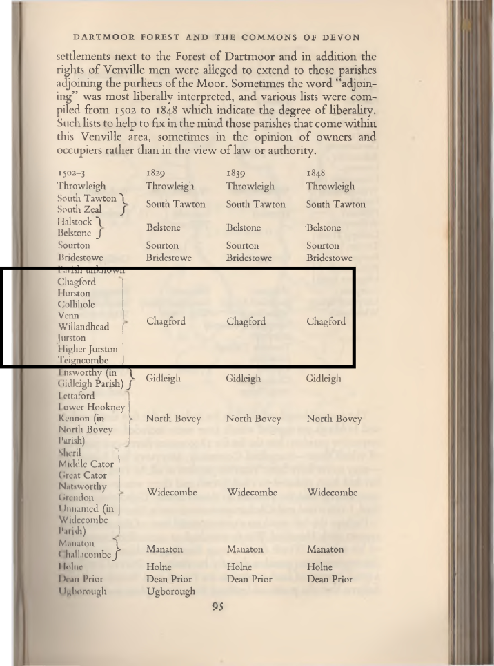
Chagford Hurston Colliholc Venn
Willandhcad Jurston
Highcr Jurston Teigncombe EnsworthyChagford Hurston Colliholc Venn
Willandhcad Jurston
Highcr Jurston Dartmoor
Of some 650 round barrows (nearly all cairns) at least 130 of the smaller ones, mostly in low-
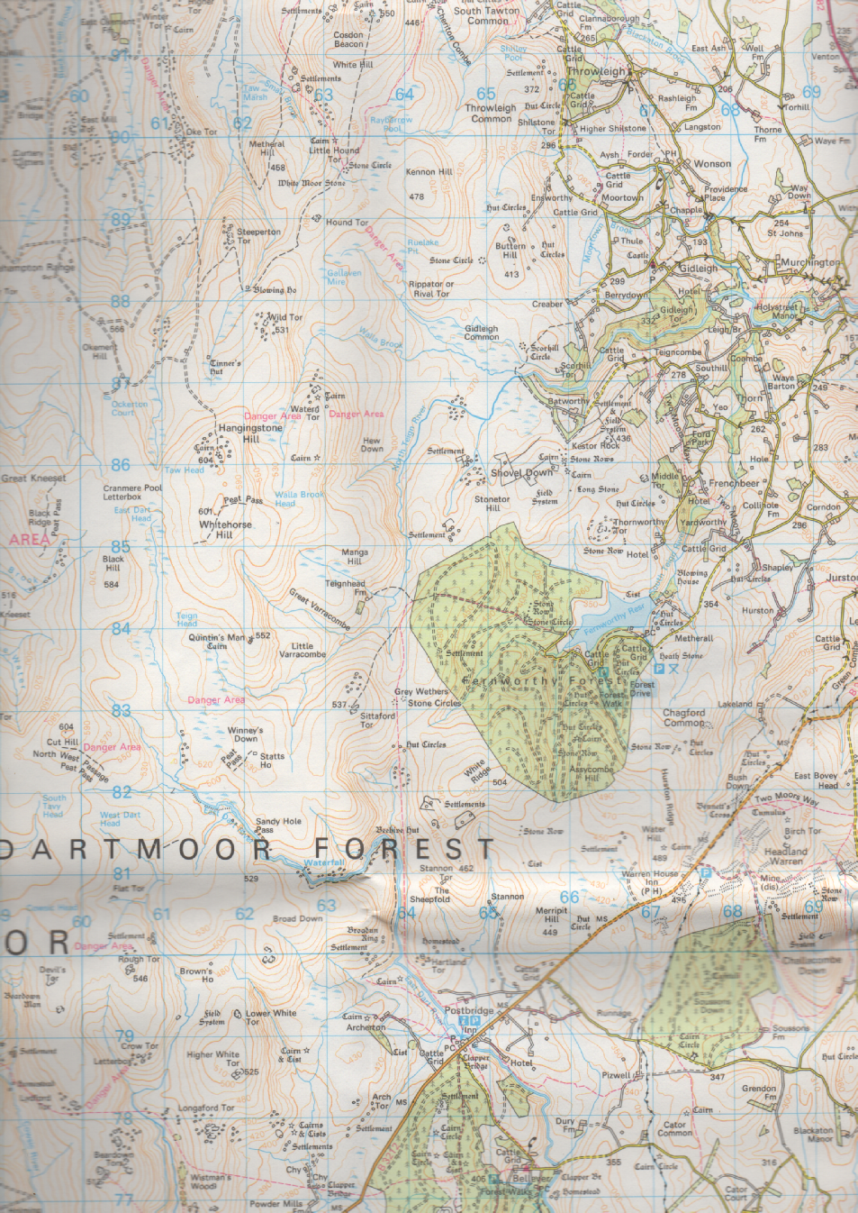
Apart from the fine cist north of Fernworthy reservoir (fig. 27) and one or two other notable sites, the more interesting cairns are on the ‘low’ moor south of the road between Tavistock and Moretonhampstead. The largest concentration of cisted cairns is around the Drizzlecombe valley in the Ditsworthy Warren and Plym Steps area, but this is difficult to reach and one has to walk a long way. A more accessible group is on Lakehead hill in the midst of Believer Forest, where the Forestry Commission has made clearances around the cairns. The best known and most often illustrated site here, a cairn with ‘above ground’ cist and retaining circle and stone row, is a conjectural restoration of the late nineteenth century.
Of the large cairns crowning many of the hills, several incorporate tors or smaller outcrops. Amongst the largest are the Three Barrows although they have been plundered for stone for centuries. The linear group on Hamel Down includes Two Barrows, the northern of which yielded in 1877 a cremation accompanied by a grooved bronze dagger and an amber pommel with gold pointille decoration (destroyed by enemy action on Plymouth in 1941).
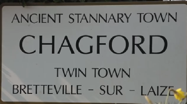
Chageyford CHAGFORD "Chageyford in the dirt"—The making of Chagford—The old clerk—The church—Tincombe Lane—Chagford Common—Flint finds— Scaur Hill circle—Stone rows—The Tolmen—The Teign river— Camps on it—Drewsteignton cromlech—Gidleigh—Old farmhouses —Fernworthy—The Grey Wethers—Teignhead House—Browne's House—Story about it—Grimspound—Birch Tor stone rows— Chaw Gully—The Webburn.
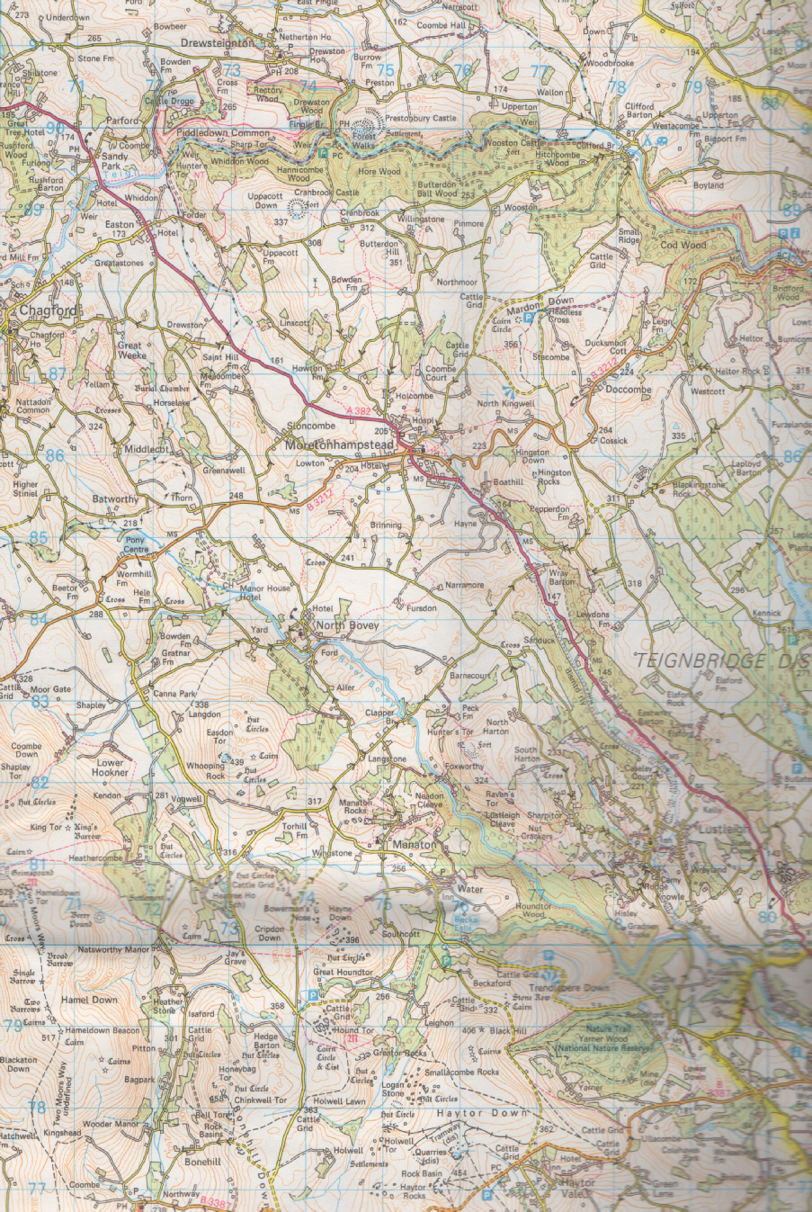
CHAGFORD is in Domesday written Chageford, and this is the local pronunciation of the name at the present day. The natives say, "Chageford in the dirt—O good Lord!" But Chagford has had the ability and promptitude to get out of the dirt and prove itself to be anything but a stick-
The ascent to the moor by Tincombe Lane, as I remember it half a century ago, was no better than a watercourse, strewn with boulders, to be scrambled up or down at the risk of dislocation of the ankle. It then well merited the descriptive lines:—
"Tincombe Lane is all uphill
Or downhill, as you take it;
You tumble up, and crack your crown,
Or tumble down and break it.
"Tincombe Lane is crook'd and straight,
Here pothook, there as arrow,
'Tis smooth to foot, 'tis full of rut,
'Tis wide, and then, 'tis narrow.
"Tincombe Lane is just like life,
From when you leave your mother;
'Tis sometimes this, 'tis sometimes that,
'Tis one thing or the other."
Now all is changed. A steam-
Chagford having lost, by death, the whistling clerk, started a blind organist. Now, also, he is gone. Every peculiarity is being crushed out of modern life by the steam-
Chagford Common, as I recall it, half a century ago, was strewn thick with hut circles. One ascended to it by Tincombe Lane and came into a prehistoric world, a Pompeii of a past before Rome was. It was dense with hut circles, pounds, and every sort of relic of the ancient inhabitants of the moor. But inclosures have been made, and but a very few relics of the aboriginal settlement remain. One of the most curious, the "Roundy Pound," only escaped through urgent remonstrance made to spare it. The road carried over the common annually eats up the remains of old, as the road-
At Batworthy, one of the inclosures, there must have been anciently a manufactory of flint tools and weapons. Countless spalls of flint and a fine collection of fabricated weapons and tools have been found there, and the collection has been presented from this place to the Plymouth Municipal Museum.
On Gidleigh Common, beside the Teign, opposite Batworthy, is Scaur Hill circle. It consists of thirty-
There was a third double row, which started from the Longstone, near Caistor Rock. This Longstone
is still standing, but the stone rows have been
Plan of Stone Rows Near Caster Rock-
Plan of Stone Rows Near Caster Rock
(Taken in 1851, Scale 1/12 in. to 10 feet.)
A. The Longstone. Hence in a northerly direction the row continued for 520 feet.
B. Cairn. C. Cairn with ring of stones.
shamefully robbed by a farmer to build his newtake walls. I give plan of the rows as taken by me in 1851. There was another line of stones leading from the Three Boys to the Longstone. The Three Boys were three big stones that have disappeared, and the line from them has also been obliterated. This portion I unfortunately did not plan in 1851.
In the valley of the Teign is the so-
The river Teign below Whiddon Park winds in and out among wooded precipitous hills to where the Exeter road descends in zigzags to Fingle Bridge, passing on its way Cranbrook Castle, a stone camp. The brook in the name is a corruption of burgh or burrh. On the opposite side of the valley, frowning across at Cranbrook, is Prestonbury Camp.
With advantage the river may be followed down for several miles to Dunsford Bridge, and the opportunity is then obtained of gathering white heath which grows on the slopes. At Shilstone in Drewsteignton is the only cromlech in the county. It is a fine monument. A few years ago it fell, but has been re-
Gidleigh merits a visit, the road to it presenting many delicious peeps. Gidleigh possesses the ruin of a doll castle that once belonged to the Prouze family. The church contains a screen in good preservation. In the parish of Throwleigh is the interesting manor house Wanson, of which I have told a story in my Old English Home.
But perhaps more interesting than manor houses are the old farm buildings in the neighbourhood of Chagford, rapidly disappearing or being altered out of recognition to adapt them to serve as lodging-
One such adaptation may be noticed in Tincombe Lane. An old house is passed, where the ancient mullioned windows have been heightened and the floors and ceilings raised, to the lasting injury of the house itself, considered from a picturesque point of view. A passable road leads up the South Teign to Fernworthy, a substantial farm in a singularly lone spot. But there was another farm even more lonely at Assacombe, where a lateral stream descends to the Teign, but it has been abandoned, and consists now of ruin only. Near it is a well-
At Fernworthy itself is a circle of upright stones and the remains of several stone rows sorely mutilated for the construction of a newtake wall. In a tumulus near these monuments was found an urn containing ashes, with a flint knife, and another, very small, of bronze or copper, and a large polished button of horn. On Chagford Common, near Watern Hill, is a double pair of rows leading from a cairn and a small menhir, to blocking -
It will repay the visitor to continue his ascent of the South Teign to the Grey Wethers, two circles of stone, of which, however, many are fallen. Here exploration, such as has been conducted at Fernworthy circle, shows that the floors are deep in ashes, and this leads to the surmise that the circles were the crematories of the dead who lie in the cairns and tunnels in the neighbourhood.
Near the source of the North Teign is Teignhead House, one of the most solitary spots in England. A shepherd resides there, but it is not for many winters that a woman can endure the isolation and retain her reason.
And yet there remain the ruins of a house in a still more lonely situation. The moorman points it out as Browne's House.
Although, judging from the dilapidation and the lichened condition of the stones, one could have supposed that this edifice was of great antiquity, yet it is not so by any means. There are those still alive who remember when the chimney fell; and who had heard of both the building, the occupying, and the destruction of Browne's House. Few indeed have seen the ruin, for it is in so remote a spot that only the shepherd, the rush-
On the Ordnance Survey, faint indications of inclosures are given on the spot, but no name is
attached. Yet every moorman, if asked what these
Grimspound, and Entrance-
Grimspound, and Entrance
ruins are, will tell you that it is the wreck of Browne's House.
The story told me relative to this solitary spot was that Browne, an ungainly, morose man, had a pretty young wife, of whom he was jealous. He built this place in which to live with her away from the society of men, and the danger such proximity might bring to his connubial happiness.
Grimspound will be visited from Chagford. The way to it after leaving the high-
Grimspound is an irregular circular inclosure containing four acres within the boundary wall. It is situated on the slope of a hill, and the position is obviously ill-
The wall itself is double-
The entrance is 8 feet wide, and no outwork was constructed to protect it from being "rushed" by an enemy. The walls of the inclosure here and throughout are from 10 feet to 12 feet thick, and stone does not exist in any part which could raise them above 5 feet 6 inches in height. Each wall is 3 feet 6 inches wide at base, and was 3 feet at top. On the west side is a huge slab set on edge, measuring 10 feet by 5 feet, and it is from 9 inches to 1 foot in thickness, and weighs from 3 to 4 tons. Other stones, laid in courses, if not so long, are not of less weight. Such a wall as that inclosing Grimspound would cost, with modern appliances and with horse power for drawing the stone, three guineas per land yard, and a land yard would engage four men for a week.
When, moreover, we consider that the circumference of the wall measures over 1,500 feet, it becomes obvious that a large body of men must have been engaged in the erection.
Presumably Grimspound was not a fortified village,
Grimspound-
Grimspound
and was merely a pound into which cattle were driven for protection against wolves. It is just
possible, but hardly probable, that it was the place of refuge for the scattered population on Hookner and Hamildon.
Within the pound are twenty-
Unless wantonly injured by trippers, it will serve to exhibit what the structure of these habitations was, with its paved platform as bed, and its hearth and vestibule.
A double hut (XVIII., XIX.) is interesting because a tall stone was erected beside it, as though to indicate it as being the residence of some man of importance, maybe the sheik of the community. In hut XVI. is a double bed, one couch divided from the other by upright stones.
In several of the huts, in the floor, are laid flat stones with a smooth surface, and it was supposed that these served as chopping-
On the col above Grimspound, near the source of Grimslake, is a cairn that contains a small kistvaen, and is surrounded by a circle of stones set upright.
Plan of Hut III., Grimspound-
Plan of Hut III., Grimspound
Numerous cairns crown the heights. One immense tumulus, King's Barrow, has at some unknown time
been excavated with great labour.
The great central trackway crosses Hamildon, and is very perfect where it does so. It had apparently no connection whatever with Grimspound.
From Grimspound may be seen, on the brow of the ridge connecting Birch Tor and Challacombe Down, a series of stone rows. They lead to a blocking-
Below is the Webburn, the stream turned up by tinners. There one mine continues in activity—the "Golden Dagger." Above is Vitifer, where fortunes have been made—and lost; mostly the latter by investors, mainly the former by the "captains" and promoters.
Near Manaton-