
Nanstallon
Roman Fort is thought to have been occupied from AD 65 to AD 79. It now remains as earthworks.
The Roman military character of the earthwork on Tregear Farm was established in excavations between 1965 and 1969.
This had been recognised in the 19th century from the many Roman objects of first century date ploughed up over many generations and listed by Iago. In the mid 19th century, the site was described as having very wide double ramparts which were gradually destroyed for field dressing and the eastern side ploughed out.
Excavations have provided evidence for a 2.2 acre fort with turf revetted ramparts, timber angle towers, metalled roads and double gates. It is thought to have been too small to accommodate a complete auxiliary unit. It probably housed a detachment responsible for the supervision of lead and silver extraction. The principia was of unusual plan, very wide in proportion to its depth. Long halls were present on either side of the courtyard and a recessed entrance and portico were present at the front of the building. The Barrack blocks were rectangular in plan with no projecting officers' quarters or verandahs. There were larger rooms present at the end of each block.The compound adjoining the praetorum was defined by a timber fence. The yard was lightly metalled with post holes suggesting the presence of lean to sheds. One possible function of the compound was that of an ablutions block.
This fort is only one area of three examples to have a double portal gate. The other examples include Baginton (Neronian in date) and Brough on Humber (Early Flavian). The dating evidence from coins and pottery suggests that Nanstallon Roman Fort was constructed late in the reign of Nero, certainly after AD 64, and withdrawal occurred during the reign of Vespasian (69-
ST. PETROC
is the great saint here. His date is the SIXTH CENTURY . and he is conjeftured to have lived from about 504 :: 590
A native of Wales, he went to Ireland and Studied there for — mm years, and then returned to Cornwall, landing at PadStcw, wheri he spent thirty years.
He then went on pilgrimage :: Rcrzc and Jerusalem, whence he penetrated as far as the great tcean river. On its shores he fell asleep, and waking, saw a bear swimming towards him.
He got into it, leaving on the shore his Staff and sheepskin mantle, and it conveyed him to an island, where for some years he led a hermit’s life.
The bowl came for him at the end of the seven years and took him back to the ocean shore. lie found that a wolf had been: guarding his Staff and sheepskin all the while, and when he set out to go back to Cornwall the wolf came with him. So a wolf is his attribute in art. Retum.sc to Cornwall, he settled at Bodmin by a holy well, and here he converted the iv ca . Constantine, who first met him when hunting a fawn, which took refuge under Petroc’s mantle. At Bodmin he died on June 4, and was buried.
King AthelStan is said to have founded an Abbey here, destroyed by are Danes in 981. A religious establishment went on somehow. Leiand sars, “ There hath bene monkes, then nunnys, then seculare preStes, then meraas agayne, and laSt canons regular in St. Petroke’s church yn Bodmine.” The regular canons (Augustinians) were established by William WarhwLsa Bishop of Exeter, about n 20. In 1177 one of the canons Stole St. Petroc’s relics and carried them across to the Abbey of St. Meen in Brittany.
Henry II was appealed to. Rclaaa be Dinan, justiciary of Brittany, was sent with an armed force to compel restitution. On June 19th the relics, enclosed in an ivory casket, were handed over to Prior Roger of Bodmin, who brought them back with great joy. The Abbot and monks of St. Meen took an oath that they had not kept back any part of the treasure, but down to the French Revolution the skull was shown there. The income of the house at the Suppression is given as £289. The grantee of the site was Thomas Sternhold, who, with Hopkins, made the old metrical version of the Psalms—that version which eventually gave way to Tate and Brady
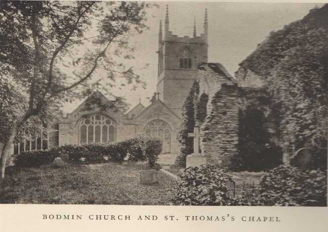
BODMIN
T. PETROC is the great saint here. conjectured to have lived from about 504 :: 594 A native of Wales ,he went to Ireland and Studied there for twenty years, and then returned to Cornwall, landing at PadStow, wherin he spent thirty years. He then went on pilgrimages to rome and Jerusalem, whe he penetrated as far as the great ocean river. On its shores he fell asleep, and waking, saw a great silver bowl swimming towards him. He got into it, leaving on the shore his Staff and sheepskin mantle, and it conveyed him to an island, where for seven years he led a hermit’s life. The bowl came for him at the end of the seven years and took him back to the ocean shore.He found that a wolf had been: guarding his Staff and sheepskin all the while, and when he set out to go back to Cornwall the wolf came with him. So a wolf is his attribute in art. Returned to Cornwall, he settled at Bodmin by a 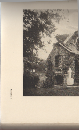 holy well, and here he converted the king Constantine, who first met him when hunting a fawn, which took refuge under Petroc’s mantle.
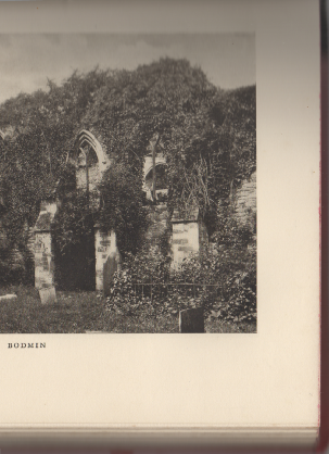
At Bodmin he died on June 4, and was buried.
King AthelStan is said to have founded an Abbey here, destroyed by the Danes in 981. A religious establishment went on somehow. Leland says, “ There hath bene monkes, then nunnys, then seculare prestes, then monkess agayne, and last canons regular in
St. Petroke’s church yn Bodmine.”
The regular canons (Augustinians) were established by William Warlwast Bishop of Exeter, about 1120.
In 1177 one of the canons Stole St. Petroc’s relics and carried them across to the Abbey of St. Meen in Brittany. Henry II was appealed to. Roland de Dinan, justiciary of Brittany, was sent with an armed force to compel restitution.
On June 19th the relics, enclosed in an ivory casket, were handed over to Prior Roger of Bodmin, who brought them back with great joy. The Abbot and monks of St. Meen took an oath that they had not kept back any part of the treasure, but down to the French Revolution the skull was shown there.
The income of the house at the Suppression is given as £289. The grantee of the site was Thomas Sternhold, who, with Hopkins, made the old metrical version of the Psalms—that version which eventually gave way to Tate and Brady.
62
Camelford Road is the nearest station for Boscastle and Tintagel.
Camelford.
Omnibus Service to Tintagel several times daily. Fare, 1/6. Also to Boscastle.
Fare, 1/6.
Hotels.— King’s Arm’s , Darlington, and several inns.
Special Coaching Excursion
The town of Camelford lies a mile and a half inland
from the station, on the banks of the Camel.
ON T HE SUMMIT OF ROUGH TOR , CAMELFORD .
Camelford is an ancient town and closely associated with the romance of King Arthur. At Slaughter Bridge , between the station and the town, the armies of King Arthur and his nephew, Mordred the Usurper, met. Mordred was killed, and the king mortally wounded. Within recent years an attempt has been made to promote the interests of Camelford as a holiday resort. Its attractions are : elevated position, being seven hundred feet above sea-
land on the other ; convenient access to Boscastle, Tintagel, Brown Willy, and Rough Tor ; numerous prehistoric remains on the Moors ; line sands at Trebarw ith 4 miles ; golf links at Rock; and trout fishing in the Camel and other streams. During the summer, brakes and carriages run to the many places of interest around . Camelford has great possibilities. Horses and vehicles may be hired at the King’s Arms Hotel. A pretty excursion can be made to the little village of Lanteglos-
Many people find the Slate Quarries at Delabole well worthy of a visit. (Train to Delabole station.) The works are quite close to the railway station.
The London and South-
from stations west of Plymouth, to Camelford, and from thence by coach to Trebarw ith Sands and Tintagel. For
full particulars of this trip, see small bills at any of the South-
GUIDE TO NORTH CORNWALL. is about eight miles further — a stiff walk. The road is taken for the first two and a half miles, until Dizzard Head, five hundred feet high, is neared, and then the cliff path does not present special difficulty.
The Valency Valley .
The deep combe in which Boscastle is situated is watered by the Rivers Valency and Jordan , affording good trout fishing (for tickets apply at the Wellington Hotel).
The valley scenery is exceedingly pretty, one side being thickly wooded. This is the favourite inland ramble from Boscastle , and it extends for about three miles. If one part of the
valley can be said to be prettier than another, it is where a second cleft in the hill leads off on the right. This double view is always admired. At the head of the last-
valley is Minster Church, in a most romantic situation. A priory once existed here , and the church was part of the Minster.
The principal Excursions from Boscastle are—
To Tintagel. Walk or Coach
To Camelford. Coach
To Brown Willy and Rough Tor.
To Launceston Castle (see p. 88).
To Crackington Haven (see p. 83).
To Trebarwith Strand (sec p. 79).
To St. Knighton’s Kieve, 3 miles (see p. 80).
To Rocky Valley, 3 miles (see p. 80).
(z) To Newquay by Coach.
Brown Willy and Rough Tor.
The moors of Cornwall are not so extensive or so elevated as Dartmoor, but they have many features in common with the Devonshire moors, together with a fine bracing air. Brown Willy, 1,375 high, and its near neighbour, Rough Tor (pronounced like Bough), 1,296 feet high, are the two principal heights , and will already have been noted from the train at Camelford.
The scenery is wild, rugged, and bleak. At the summit of Rough Tor are some grandly piled rocks of huge size. Some rather rare ferns, in particular the Filmy Fern
(Hymenophyllum uniiterate) are found on these heights.
B0SCASTLE.
i 85
Approaches.— From Camelford Town: Go over the bridge and in a few minutes bear off on the right along the ascending road leading almost straight to the heights. Rough Tor is first
reached. Here are some fine rocks and innumerable Stone Circles. Brown Willy is a mile and a quarter beyond. The bog between them should be carefully noted and avoided.
frith Co., Ltd. Reigate.
st . Knighton’s kieve .
The total distance is about five miles from Camelford, from whence vehicles can be hired.
From Boscastle or Tintagel:
Coach to Camelford station, then walk to Camelford
1, 1/2miles and proceed as above. Vehicles can be hired to drive all the way.
Castle an Dinas, an Iron Age hillfort.
the Nine Maidens stone row, the largest row of standing stones in Cornwall ;the Devil's Quoit is sometimes recorded as King Arthur's Quoit in the hamlet of Quoit , and King Arthur's Stone said to be not far from the Devil's Quoit near St. Columb , on the edge of the Goss moor). It was a large stone with four deeply impressed horseshoe marks. Legend has it that the marks were made by the horse upon which Arthur rode when he resided at Castle An Dinas and hunted on the moors.
King Arthur's Hall is a megalithic enclosure on Bodmin Moor in Cornwall, England.
It is thought to be a late Neolithic or early Bronze Age ceremonial site.
King Arthur's Hall on Bodmin Moor
The monument consists of fifty-
The surrounding area contains many stone circles, hut circles, cairns and cists.
In the absence of any archaeological finds, its origin and use is only speculative. A similar enclosure exists in Brittany which was a Bronze Age cremation site, but a similar rampart construction at Lough Gur in Ireland suggests an earlier Neolithic date. It has even been suggested that it was merely a medieval cattle pound, but the effort required to build the bank and to erect the slabs suggests that it had a more important function.
Some clearance and investigation of King Arthur's Hall was conducted by members . Their work revealed a revetment wall built to retain the inner bank. It was concluded that over time the earth had covered over the top of the revetment wall and that around 140 upright stones now lie buried, recumbent, or standing at an angle. It was suggested that the structure originally formed a tank which filled with water, possibly for ritualistic use.