
Roman Calstock
A curiosity for the historically inclined – it was always believe that there was really not much Roman presence in Cornwall. But in 2008, an excavation looking for traces of medieval silver mining found instead an enormous first-
The site of Calstock Roman Fort probably dating from the 1st century AD.
This is only the third Roman fort to have been found in Cornwall and the first with possible associations with Roman military interests in Cornwall's mineral resources.
The site is located on a spur above the river Tamar near to St. Andrew's church in the parish of Calstock, Cornwall.
It was found accidently by a team from Exeter University, as part of the larger Bere Ferrers Project, investigating the development of medieval silver mines in this area.
A geophysical survey in 2007 revealed the outline of a Roman fort enclosed by two ramparts and two ditches. A number of anomalies were also revealed which may be associated with Roman metalworking.
In 2008 a trial trench was excavated on the site which revealed details of the fort's defences.
The fort measures circa 170m by 160m, with an internal area of circa 140m by 130m (1.82 hectares). This is much larger than the other two known Roman forts in Cornwall; Nanstallon (Monument Number 431370) and Restormel (Monument Number 432777).
Two ramparts and ditches were uncovered. The outer rampart is approximately five metres wide and is constructed of clay and shillet from the digging of the ditches. The sides of the rampart were held together with timbers on both faces. Two ditches were uncovered between the inner and outer rampart with characteristic v-
Finds from it included Roman pottery, fragments of furnace lining and some ore and slag which suggest that Roman metalworking was taking place in the 1st century AD. A track leading into the fort was also identified.
Twisting and turning upon itself in great loops and bends, the river Tamar between Gunnislake and Plymouth flows through a hilly and tumbled valley rich in surprises. Half in Cornwall, half in Devon, its unusual and varied scenery is among the least known in the country and it hides relics of an industrial past hardly known outside Devon and Cornwall.
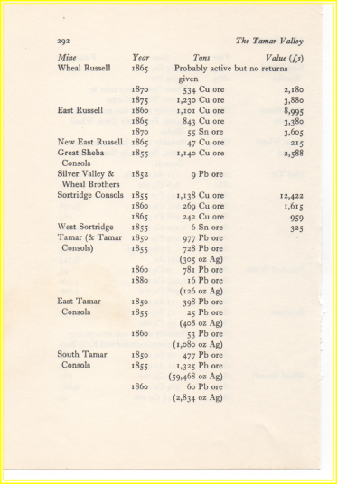
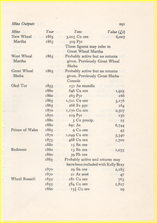
The Tamar Valley today is devoted to agriculture, but in the 1850s and 60s it rivalled West Cornwall in importance as a source of copper. For nearly thirty years after that it was the centre of arsenic production in the British Isles, and it had long been recognized as an important area of lead and silver mining. At a time when ships were changing from sail to steam, furnace-
All these industries—one employed over a thousand people while others were little more than family enterprises—grew up in an isolated countryside where people lived in close contact with their surroundings. Its compact and close-
Today Calstock has one of the highest unemployment rates in Devon and Cornwall; one quarry works where once there were ten. But between the 1860s and 80s a man living there could have been housed, clothed and shod with bricks, serge1 and leather produced within a mile of its quays. Paint coloured by ochre produced from
 The site of Calstock Roman Fort probably dating from the 1st century AD.
This is only the third Roman fort to have been found in Cornwall and the first with possible associations with Roman military interests in Cornwall's mineral resources.
The site is located on a spur above the river Tamar near to St. Andrew's church
in the parish of Calstock, Cornwall.
It was found accidently by a team from Exeter University, as part of the larger Bere Ferrers Project,
investigating the development of medieval silver mines in this area.
A geophysical survey in 2007 revealed the outline of a Roman fort enclosed by two ramparts and two ditches.
A number of anomalies were also revealed which may be associated with Roman metalworking. In 2008 a trial trench was excavated on the site which revealed details of the fort's defences.
The fort measures circa 170m by 160m,
with an internal area of circa 140m by 130m (1.82 hectares). This is much larger than the other two known Roman forts in Cornwall; Nanstallon (Monument Number 431370) and Restormel (Monument Number 432777). Two ramparts and ditches were uncovered.
The outer rampart is approximately five metres wide and is constructed of clay and shillet from the digging of the ditches. The sides of the rampart were held together with timbers on both faces.
Two ditches were uncovered between the inner and outer rampart with characteristic v-
They were 2.8m deep and approximately 3.5m wide. The outer rampart was also approximately five metres wide and the investigations show that it was capped with large sandstone rubble on the western and southern sides of the fort. Just outside this rampart a stone-
Finds from it included Roman pottery, fragments of furnace lining and some ore and slag which suggest that Roman metalworking was taking place in the 1st century AD.
A track leading into the fort was also identified.
Calstock Roman fort
Dr Chris Smart, Professor Stephen Rippon and Dr Peter Claughton
Geophysical survey carried out by Chris Smart and Dr Peter Claughton, Research Fellows in the Department of Archaeology at the University of Exeter as part of the Bere Ferrers Project (directed by Professor Stephen Rippon) has led to the discovery and excavation of a previously unknown Roman fort. The site, situated on a spur above the River Tamar on the border between Devon and Cornwall, is adjacent to St. Andrew’s church in the parish of Calstock.
The Bere Ferrers Project has, over the past two years, been investigating the development of the royal silver mines which were worked on the Devon bank of the Tamar between 1292 and the mid 16th century. While the mining of ore was restricted to the localised deposits in Bere Ferrers parish, the processing of that ore was carried out away from the mines close to woodland which supplied fuel for smelting and refining. Documentary evidence suggested that smelting was carried out near to the church of St. Andrew in the parish of Calstock on the Cornish side of the Tamar when woods there were allocated to the mines as there are references to smelting and refining at a curia ‘next to the church’ and vetus castrum de Calistok (‘at the old castle/fort at Calstock’). It is known that this curia was an earthen-
In the summer of 2006 a high-
In the autumn of 2007, a magnetometer survey was conducted of a larger area with the specific goal of identifying the locations of furnaces associated with the medieval industry. This survey gave greater clarity compared to the resistivity results, and revealed the distinctive outline of a Roman fort enclosed by two ramparts and two ditches,. Significantly, a number of anomalies also hinted at the potential sites of smelting furnaces known as ‘boles’. Our sponsors, The Leverhulme Trust, kindly agreed to fund an archaeological evaluation of the site, led by Chris Smart, over two weeks in January 2008. This evaluation had two key aims: first to date the construction of the fort and second to examine the possible medieval smelting bole.
A single evaluation trench measuring 2m by 45m was positioned to expose a section across the fort’s defences as well as the potential smelting bole. As the field in which the excavation took place was under permanent pasture and had not been ploughed in the recent past, it was expected that the preservation of in situ archaeology would be good. Overall, the fort measures c.170m by 160m, with substantial defences leaving an internal area of c.140m by 130m (1.82 hectares). Comparison with the internal areas of the two other Cornish forts, Nanstallon (0.72 hectares) and Restormel (0.42 hectares), demonstrates that the fort at Calstock was constructed on a much larger scale. The trench was cut a short distance into the interior of the fort, revealing a possible oven and stoking chamber. Its position, against the inner rampart, would have minimised the risk to the timber buildings, and is a typical feature of Roman forts. Pottery of various types was recovered from the oven and overlying deposits, and may give an indication of the length of use of the site.
Excavation revealed an inner rampart approximately 5m wide, constructed of clay and shillet cast from the digging of the first ditch, and revetted with timbers on both faces. The outermost revetment was constructed of worked timbers 30cm square, suggesting that they may have formed the basis for a timber super-
Investigation of the geophysical anomaly to the south of the fort defences may corroborate this hypothesis. Prior to excavation it was conceived that this may be the location of a medieval smelting bole referred to in fourteenth century accounts. The feature presented itself as a square or rectangular (it was not fully revealed) stone-
Post-
Calstock Roman Fort probably dating from the 1st century AD.