Modern people have inhabited the Somerset region of southwest England since the Devensian. During this time and the succeeding Mesolithic they lived in and/or made use of places like the caves of the Mendip hills, at Gough's (New) Cave and Aveline's Hole for example. In the following Neolithic a shift was made to farming and permanent settlements emerged. It is known that to the south of the Mendips substantial activity occurred on the Somerset Levels, via the Sweet Track for example [Coles et al. 1973].
The Sweet Track was a timber walkway created circa 3800BC to enable people to cross the marshes of the Brue Valley near Glastonbury. Shortly after this period chambered tombs appeared in the area, followed by henge monuments, and then by the Wedding Stones at Stanton Drew. This paper re-examines the complex in the light of geophysical surveys at Stanton Drew, highlighting missed details, before suggesting multiple lunar alignments within the much under-valued megalithic complex. The monuments at Avebury and Stonehenge are then examined and a close association between the users of all three sites is proposed.
2.1 Chambered Tombs
The Somerset region is associated with one of the best-known forms of Neolithic chambered tomb - the Cotswold-Severn group.
Two main sub-types exist: transepted long chambered tombs, containing a number of compartments/transepts opening on both sides from a central passage (e.g. Stoney Littleton, Somerset); and another, lateral tombs, in which the compartments are placed with entrances along the side, a symbolic dry-stone entrance placed in the centre (e.g. Belas Knap, Gloucestershire). The lateral tombs may slightly predate the former [Lynch 1997, p.54]. Many tombs appear to incorporate earlier cairns (e.g., Notgrove, Gloucestershire) implying a gradual spread of the "Somerset culture". Burl [1983, p.21] has noted how almost all Cotswold-Severn tombs have their central entrances aligned between northeast and southeast, signifying an interest in celestial movements by the builders. Disarticulated human remains have been found in the compartments of many such tombs [e.g., Bulleid 1941]. Nearly a dozen examples exist in the area around Stanton Drew, including those at Redhill, Butcombe and Dundry. Such structures perhaps functioning as localised representations of previously sacred caves when people spread out over the landscape due to farming and/or overcrowding.
This distinct form of chambered tomb appears to be centred on the Mendip area, ranging up into Gloucestershire and north Wales, as well as east to Wiltshire, suggesting an influential Somerset community. Numerous examples also exist to the west, in south Wales, near Cardiff (e.g., Tinkinswood) and in the Gower (Parc Le Breos), across the opening of the Bristol Channel from the Somerset Levels. Further, it appears that most tombs are within site of at least one other, e.g., Redhill and Butcombe; a new feature of Cotswold-Severn tombs can be noted.
2.2 Henges
A particular form of henge also appears centred in Somerset containing an outer ditch and inner bank, known as Type B [Burl 1991, These can be found in the same areas as the Cotswold-Severn tombs, on the Mendips (Priddy) and in north Wales (Llandegai North), as well as further afield from the identified regions: north and west of Wales, on Anglesey (Castell Bryngwyn) and near Dublin (Longstone Rath) respectively; further into Wiltshire, at Stonehenge (modified along its outer edge); and significantly north of Gloucestershire, in Cumbria (Penrith). Burl [ibid., p.16] suggests that henges were used both for ceremonial and trading purposes, often with regional types built in other areas specifically for the latter (in safety), which may explain the siting of such out-post henges. The multiple-type henge phenomenon occurs on the Mendips at Priddy where a north-northeast alignment of three Type B henges can be found, with a fourth partially constructed henge of the same type nearby, and two henges of a different type within a six-mile radius. The alignment of three Type B henges is slightly less than perfect.
Burl [ibid.] has also suggested that the cardinal location of a henge entrance may be significant to the location of its users. The two northern most of the roughly aligned Type B henges at Priddy have their entrances to the north, whilst the third has its entrance to the south. On this basis it can be speculated that the north-entrance henges were for the related communities in north Wales and Gloucestershire, whilst the south-entrance henge was for the local community of Somerset and south Wales. That a fourth Type B henge was abandoned mid-way through construction indicates a change in the belief system. Alternatively, the "unfinished" ring may be a deliberate earthwork semi-circle or horseshoe akin to one found in Moray for example (see [Burl 1999, p.152-153] for discussion of horseshoes).
2.3 Standing Stones
Wimblestone is perhaps the most well-known standing stone in Somerset, situated just under a line of trees at the western end of a valley whose northern edge was the site of a Neolithic settlement [Clarke & Richards 1972]. The stone is around 2m tall and an equilateral triangle in shape, roughly 0.5m in width, and at its base is an oval hole. This huge shark's tooth is aligned such that its thinnest aspect points east/west. To the west is a sharp rise onto the Mendips at Dolebury Warren, not far from Aveline's Hole. At the other end of the valley, in Banwell, is another megalith of the other type found in the region - a large, flat, rectangular stone. This megalith is about 2m high, 1.5m wide, and 0.5m thick. Its top edge is rain-damaged and looks as if a corner is missing. The thinnest aspect points to Fry's Hill with its raised end, which leads up onto the Mendips near Cheddar Caves. Hence such stones can be seen as signposts to the henges at Priddy. It is also interesting to note that, standing at the Banwell stone's raised edge, facing south-southwest and hence perpendicular to it, the prominent Brent Knoll appears cradled between two closer hills. The huge, almost conical, Brent Knoll stands alone over a hundred metres proud of the western end of the Levels. It lies on an azimuth of 211 degrees from the Banwell megalith, that of the major southern setting of the midsummer moon. The minor southern setting may be seen directly to the right of its base, an azimuth of 231 degrees. Viewing the major southern setting over something is seen at Stanton Drew (Section 3) and further afield (Sections 5 and 6). It can be further noted that a similar alignment can be found in Trencrom, Cornwall where the southern setting of the midsummer moon is seen over Trencrom Hill from a nearby megalith.
Old Ordnance Survey maps from the 1880's show the position of a stone called the Hundred Stone at Chapel Allerton, in the Somerset Levels. To the north-northeast lies Fry's Hill and the southern edge of the Mendips. It too had a clear view of Brent Knoll, its base appearing larger than at other angles. Hence it may be speculated this stone was a flat rectangle aligned north-northeast/south-southwest. In the 1700's William Stukeley reported a stone of the same shape near Chew Magna, in the Chew Valley a mile west of Stanton Drew [Burl 1999, p.55]. This early survey may explain the suggestions of a stone circle there, west of the fork in the River Chew from Chew Lake [e.g., Darvill 1985, p.16]. The Mendips are to the south-southwest, suggesting the stone was aligned north-northeast/south-southwest. The nearby Round Hill appearing almost conical with a view perpendicular to this orientation.
Many more stones of these two types, now lost, must surely have existed in Somerset, encircling the Mendips to direct the prehistoric traveller. Their shape is reminiscent of the proposed male/female stones of the Kennet Avenue at Avebury.
2.4 South Wales
It was noted above that the Somerset culture/community existed in Wales, with the building of their distinct chambered tombs. The closest example is just outside Portskewett, on a small knoll above the banks of the Severn, between the two bridges which cross from England into Wales. Since the sea levels were lower for much of the Neolithic and both bridges are built on prominent rockbed, it seems likely that the area was also a prehistoric cross-point. The long barrow has clear views of the estuary, with the top of the Mendips just visible to the south. Its stones are full of pink quartz pebbles.
Standing stone signposts can also be found in the vicinity. Three miles southeast of Portskewett, near St Brides and Magor, is a triangular and pointed stone slightly larger in stature than Wimblestone. Just a few metres from the M4 link to the second Severn crossing, this monolith is aligned roughly east-northeast/west-southwest, suggesting a nearby crossing of the Bristol Channel/Severn. Another stone of this type can be found further north in the beginnings of the Usk Valley (Llangybi), where a large monolith stands in the middle of a field, aligned southeast/northwest. Here the southeast direction indicates the nearest crossing to the cultural/religious centre of Somerset for the north Wales traveller. An enormous rectangular stone, almost 3m tall, can be found aligned east-northeast to the Magor stone fifteen miles away to the south near Castleton. The view west-southwest, i.e., perpendicular and from its raised end, is of a distant Brent Knoll cradled between two hills.
Again, many more such stones must surely have existed nearby to direct the prehistoric traveller from Wales to the Mendip region showing, as do the long barrows, an intimate relationship between the inhabitants of the two regions.
In John Aubrey's time, back in Somerset, a large rectangular outlier at Stanton Drew, known as Hautville's Quoit, could be seen. Today it can be found lying, much diminished, behind a roadside hedge.
3. Stanton Drew
The megaliths at Stanton Drew are arranged in three circles, two of which have short avenues, with a nearby Cove and an outlier. Local folklore tells of a wedding party lured by the Devil into celebrating on the Sabbath and being petrified for such activity. The main circle is over 110m in diameter, making it smaller only than the outer circle at Avebury 25 miles east, and originally consisted of approximately thirty 2.5-3m long stones. A short avenue extends from its east-northeast towards the banks of the nearby River Chew. From the entrance to this avenue extends another into a circle of around 30m in diameter to the northeast of the main circle. This circle consists of eight slightly larger stones than those of the main circle. To the south-southwest on a small knoll above these two circles lies the third circle, roughly 44m in diameter, consisting of twelve slightly shorter stones. A Cove of three large stones is southwest of the main circle, with the backstone fallen, and the outlier 512m to the north-northeast of the main circle, previously over 3m long. All measurements are taken from Burl [1999, p.52-53].
An alignment stretches from the Cove, through the centre of the main circle, to the centre of the northeast circle, at around 52 degrees from north [Burl 1987, p.14-16], which will be returned to here. A second alignment exists from the centre of the northeast circle to that of the south-southwest circle, with an azimuth of 211 degrees and a declination -30.9 degrees, it marks the major southern setting of the midsummer "Moon?" [Thom 1967, p.100 S3/1]. A final alignment exists from the centre of the south-southwest circle, through the main circle, to Hautville's Quoit, which appears to emphasize the barrow-shaped Settle Hill.
Burl [1999, p.62-63] suggests the Quoit and Cove came first, followed by the main stone circle, then the south-southwest circle, then the northeast circle, and finally the avenues to the banks of the river were added. Note that the latter possibly signifyies the importance of water in the belief system. The points made above would appear to support an early Quoit, i.e., it was originally positioned to indicate the shortest route to the Mendips (south-southwest) over Chew Valley near Ubley. Hence the alignment was the same as that of the Chew Magna monolith. It also provides the first clear view of the prominent Maes Knoll for the traveller from the east; again, a seemingly conical local hill would have been marked by a view perpendicular to the female/flat monolith. The top of Maes Knoll appears to move across the back of Settle/Guy's Hill just before the Quoit is reached.
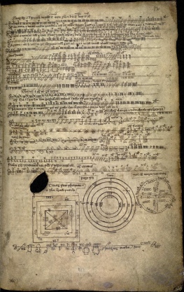
In 1997 English Heritage undertook geophysical surveys of the two avenued circles at Stanton Drew (Fig. 1 - note the north shown is in error by over ten degrees). The results indicated a 7m wide ditch previously surrounded the main circle, with a large opening to the northeast. Within the stone circle existed nine concentric rings of pits, ranging in diameters from about 23m to 95m, which probably held (over 400) timber poles of around 1m in diameter. Five other pits were also found in the central area of the rings. In the northeast circle four pits were discovered in a quadrilateral aligned with opposing pairs of the standing stones and a further two pits were found just in front of where the avenue joins the circle; a smaller version of the monument appears to have existed before the one now seen.
The timber rings do not appear to have been equally spaced, rings eight and nine from the centre being significantly separated from ring seven for example, perhaps indicating they did not all stand concurrently. The rings are placed directly south of Maes Knoll, on the most level ground of the lowland area. That the centre of the timber rings is aligned with the Quoit and the small knoll to their south-southwest implies the Quoit may have been raised at the same time, reinforcing Burl's suggestion that the Quoit predates the stone circles. That is, the monolith signposts of the region were raised around the same time as the construction of the timber monument otherwise the Quoit represents a later example of the tradition. The timber rings were perhaps the reproduction of a previously sacred forest clearing and through which the subtle movement of celestial bodies could have easily been noticed.
Examination also shows that a southwest section of the outer ditch did not appear on the survey, although the English Heritage results "assume" its existence. It has already been noted than an alignment exists between the centre of the main circle, the centre of the northeast circle, and the Cove. The Cove is therefore away to the southwest of the main circle. With a 7m wide ditch the resulting bank would have been large - one of its roles was probably to block any external view. Therefore it seems likely that the gap was deliberate to allow a view from, and direct passage from, the Cove.
Closer examination also suggests that the concentric timber rings do not share the same centre as the following stone circle and ditch. Indeed, the centre of the stone circle and ditch is some metres north-northwest of the timber monument centre. This may be explained by the need to refine the south-southwest circle (knoll) to Quoit alignment, suggesting the Cove was built at the same time as the stone circles rather than before. The centre of the stone circle and surrounding ditch is actually marked by the middle "anomaly" of the five found in the main circle. From this newfound stone circle centre an alignment exists with the centre of the northeast circle which passes directly through the middle of the aforementioned gap in the ditch to the Cove; the view, aligned along the left bank of the gap, has an azimuth of 231 degrees - that of the minor southern setting of the midsummer moon.
As a very speculative aside: The timber rings may not share the same centre as the stone circle because they predate it by a significant amount of time. The posts were obviously large and in a very large ring. This makes them similar to the timber posts found under the carpark at Stonehenge, which have been dated as Mesolilthic [Cleal et al. 1995]. That is, the stone circle may have been built at a previously important site.
It can also be noted that the larger gap in the ditch allows all of the stones of the northeast megalithic monument to be viewed from the main circle (between the stones at least). Hence the ditch must have been added after the northeast circle and the avenues were raised; the proposed henge was the final contribution.
4. Further Alignments
The Cove at Stanton Drew was probably built as a symbolic representation of the chambers of tombs of the region [Burl 2000, p.31], with a very rough alignment to the major southern midsummer moonrise - an azimuth of 149 degrees [Burl 1999, p.54]. The huge back slab has fallen outwards and broken. The two sides are still standing, that to the northeast being signifcantly large than its partner. Indeed, it is suggested the opposite stone is from the larger due to their apparantly matching shapes (the broken back stone would now provide two large stones of similar shape). The southeastern Cove side rises to a point about 1.5 metres high. The view over this point would be directly to the centre of the main ring and that of the northeast ring beyond; the view is of the aforementioned alignment and most certainly deliberate. The midswing of the midsummer risings may be marked by a stone in the main circle but chances of a coincidental alignment are of course high.
The timber rings at Stanton Drew were replaced by a huge stone circle, with an apparent central stone. The other four anomalies in the circle's centre may also have held (smaller) stones at a later date, with the centre stone being removed. Alternatively, they may have been ceremonial pits akin to those seen around the Obelisk at Avebury.
A significant gap in the stones occurs to the ring's northwest. The positioning is such that it is aligned to roughly 'window' the full swing of midwinter moon settings, azimuths of 299 to 319 degrees, viewed over the Dundry hills; the stones may be missing by design.
Inspection at the site suggests that the stones themselves may alternate between having flat and pointed tops thereby representing a continuation of the region's standing stones (section 2). As noted above, such design can be seen in the Kennet Avenue of Avebury, and also in the portalled entrance to the Rollright Stones in Oxfordshire, in the Bluestones at Stonehenge, and other sites.
The northeast circle is constructed of the largest and darkest coloured stones. It is orientated at roughly 52 degrees from the centre of the main circle (Fig. 1). The alignment, backsighted by the Cove, passes over a stone of the main circle and inspection shows this almost fallen stone to be smaller than the (discernible) others, with a flat top. That is, it seems a view of the centre of the northeast circle was planned from the outset rather than the smaller ring being added much later with some difficulty on its slope (as suggested in [Burl 1999, p.62]). The reason for the landscaping being the requirement that the enormous main circle, like the timber rings before it, sit directly south of Maes Knoll. There is an area of flat ground between the ring and the main ring, suggesting it was deliberately placed back to provide a better view of it from the main ring; the main ring, by its size, suggests a large number of users, each presumably requiring a particular view to the northeast. The alignment over the south-southwest circle must also have played an important role in its positioning [ibid., p62]. The northeast ring was initially smaller, laid out as an almost perfect square, each pair of stones straddling a major cardinal axis, and with the same centre as the later ring. From the centre of the main circle, looking to the left of the (smaller) northeast stone, the orientation is close to 51 degrees from north. This is the azimuth of the mid-point between the moon's major (41 degrees) and minor (61 degrees) midwinter northerly risings as it progresses over its 18.61 years cycle. When the smaller circle stood a 'slot' between its two closest stones and the left edge of the flat-topped main circle stone existed. At midswing the moon would appear to rise directly above this slot on the near horizon - a lunar equivalent of Ruggles' [1997] "solar corridor" idea.
A larger version was built by laying two rectangles at 45 degrees to the square (southeast-northwest and southwest-northeast) such that their long sides passed just outside the original's corners. Again, pairs of stones straddle the major cardinal axes but further out from the centre to create a larger ring of eight stones. The long sides are therefore at rightangles to the framed original's southwest-northeast diagonal. When the larger monument was constructed the slot at 51 degrees from the main circle was maintained. Further, the circle is of such a diameter that azimuths of 41 and 61 degrees just pass its outside edges. The 41 degree alignment is slightly further from the circle but this may be explained by a gentle rise in the horizon due to Settle Hill. The lunar movements are also tracked more closely by two other slots constructed between the main circle stone and northeast ring stones at 46 and 56 degrees. The midsummer sun rises over the stone closest to the main circle (50 degrees).
Therefore, in summary, from the main circle the midwinter risings and settings of the moon can be seen and tracked over their 18.61 year cycle, the risings in particular. From the Cove the midsummer risings can be seen, though their tracking is very approximate, with the midsummer settings observable from the northeast circle, moving from above the south-southwest circle on a small knoll, to the Cove. An outlier provides emphasis on hills to the north, in particular a barrow-shaped hill and the seemingly conical hill known as Maes Knoll. Hence the Wedding Stones appear to maintain an interest in the movements of the moon, as seen in the chambered tombs of the region.
5. Avebury
The similarities between the megaliths of Stanton Drew and Avebury have been noted since Stukeley's time. This section explores a close association between the two communities, the Sanctuary in particular is suggested as being closely analogous.
5.1 Windmill Hill
To the north of the Kennet Valley is the early Neolithic settlement of Windmill Hill, which has views across the whole valley. Windmill Hill began as an open settlement, with what appears to have been seasonal use [Malone 1989]. Pieces of imported rock (oolitic limestone) and pottery from the Bath area have been found from this time [Smith 1965]. Three concentric rings of ditches were dug to form a causewayed enclosure. The ditches are on the outside of the banks, as in the later henge monuments to emerge from Somerset. The site was very probably used for fertility/religious ceremonies, feasting, and trade [e.g., Malone 1989], much as later henges were. In general causewayed enclosures appeared in southern Britain [Darvill 1987], in various styles/sizes, perhaps as territorial markers for emerging farming communities, with exceptions found in Yorkshire and Norfolk, and a concentration in the west. Other examples include the nearby, similarly styled and contemporary to Windmill Hill, Knap Hill upon which Cotswold sherds were found and Crickley Hill in Gloucestershire, which seems to have had a mainly defensive function [Bewley 1994]. Indeed, Knap Hill on the southern edge of the Marlborough Downs may have been a defensive post overlooking the Vale of Pewsey north of Salisbury Plain.
Therefore it seems plausible that Windmill Hill was the site of the Somerset community frequently visiting, possibly even settling in, the Avebury area. Initial impetus to such visitations perhaps coming from trading. The site then became a place of congregation for both communities; religious and social ties were formed. The next stage of monument building contains strong evidence of close association.
5.2 The Kennet Long Barrows
The huge West Kennet and East Kennet long barrows are chambered tombs of the Cotswold-Severn style. In both monuments oolitic limestone from the Bath area was used in the construction of the chambers. Other chambered tombs in the region, such as Adam's Grave, also contain such stone; the practice was not limited to the two largest tombs. This was obviously very deliberate and so of great import to the tomb builders.
5.3 Timber Feature in the Main Circle-Henge
It seems likely [Bewley et al. 1996] that a double-ringed timber monument existed in the north-northeast area of the huge Avebury earthwork. The view from the rings over the Obelisk of the south circle is to the barrow-shaped Waden Hill, assuming the banks came later as at Stanton; the Obelisk may predate its cohorts and fulfill a similar role to Hautville's Quoit (Burl [2000, p.322] notes a similar view from the Ring Stone).
5.4 Stone Features in the Main Circle-Henge
Two adjacent circles were raised to the south of the timber rings, reminiscent of those at Bathampton (east of Stanton Drew - see [Quinn 1997] for a description). The southern circle was arranged around the aforementioned Obelisk; that the huge stone is slightly off-centre supports this sequence of events. The resulting monument would have been reminiscent of the main ring at Stanton (although a monolith was perfectly central there).
The Cove at Stanton provides a rough lunar alignment. The remains of an enormous Cove stands north-northwest of the south circle within the main second circle at Avebury. It appears to be very roughly aligned on the midsummer sunrise [Burl 2000, p.320]. A second Cove was reported by Stukeley as part of the Beckhampton Avenue - only the sideslabs known as Adam and Eve can be seen today. This Cove may have been aligned on the midwinter sunrise [ibid.]. Both Stukeley and Aubrey reported a third Cove as part of the Kennet Avenue, although nothing can be seen today. It seems likely it roughly faced the midwinter sunset over Waden Hill. A fourth Cove facing northwest and the midsummer sunset over a hill/rise can be expected.
The "solar" Cove in the northern circle was surrounded by a Sarsen horseshoe [Ucko et al. 1991]. Significantly, a Sarsen horseshoe was built within the lintelled Sarsen ring at Stonehenge as part of the shift in the monument from being lunar to solar (see Section 6). Hence it appears that there was a solar emphasis to the megaliths in the Kennet Valley. However, a lunar monument was built nearby, apparently following developments at Stanton Drew.
Later the enormous earthwork was dug and stones raised around its inner edge. It can be noted that, given the lack of Neolithic artefacts found within the earthwork, a defense/encampment purpose, as suggested in [Burl 2000, p.323], seems unlikely.
5.5 The Sanctuary
The Sanctuary (e.g. see here), up on the eastern edge of the Kennet Valley, has traditionally been seen as a multi-phased, multi-ringed timber circle before two circles of stones replaced the poles [Malone 1989]. Its similarity to the early timber (ditch-less) monument at Stanton Drew is therefore clear. Pottery from the Sanctuary is also contemporary to that found within the Kennet tombs and Windmill Hill.
Each phase of building at the Sanctuary effectively enlarged its outer diameter. These phases consisted of many posts and hence coincidental alignments are extremely likely. Building in Phase I consisted of eight relatively small posts in a ring and a central post. It is interesting to note that two of the four ring posts in the western half of the 4m ring roughly mark the major northern midwinter setting of the moon and the minor midsummer setting - azimuths of 319 degrees and 231 degrees respectively. Two of the four posts in the eastern half are very close to the midswing azimuths of the midwinter and midsummer risings. The remaining posts appear to be roughly equally spaced between these four, with all posts being around a metre apart; access to the centre was easy.
The smaller ring of Phase II (ring E) seems to have been constructed from larger posts but maintained the same centre as Phase I. It also maintained the forerunner's westerly lunar alignments, actually marking them more accurately. Pitts [2000, p.244] has suggested the posts of this phase were continually moved as part of a ritual. However, an alternative explanation is the wish to accurately capture the significant lunar events after their initial approximation during Phase I. On the east two posts were aligned on the minor midwinter risings and major midsummer risings, i.e. replacing the very rough midswing alignments. Again, the remaining four posts can be seen as equally spaced from the lunar markers. The outer ring of Phase II (ring D) contained twelve posts. Two in the western half maintain the lunar setting alignments of the previous rings. In the eastern half the midswings of Phase I were again marked but more accurately than before. The remaining eight posts were equally spaced to form the circle. That the postholes of these two phases had similar depths [Lees 1999] supports related development.
In Phase III three concentric rings existed, again with the same centre as the other phases; it seems likely all phases stood in quick succession. Within this phase a large number of posts were raised and, as such, claiming deliberate alignments is again difficult. However, a few can be proposed with some justification. Pitts [2000, p. 284] noted an anomaly in post spacing in the outer ring (ring B), presumed to be a fence, at the northeast. With an azimuth of around 50-51 degrees he suggested it marked the midsummer solstice. This is also close to the midswing of the moon's midwinter northerly risings. The posts either side of this marker are on azimuths of 46 and 56 degrees which can also be seen at Stanton in the northeast ring (Section 4) as part of its suggested tracking of the moon's movements over the 18.6 year cycle viewed from the main ring. Hence lunar alignments may explain the feature highlighted by Pitts. Burl [2000, p.314] has noted how a Sarsen added to the outer fence marks the major southern midsummer setting to the south-southwest (over it), the stone possibly also forming part of an entrance [e.g. Pitts 2000, p.285]. The western-most post of the suggested entrance to the Sanctuary, significantly closer to its neighbour than its eastern counterpart, roughly marks the minor southern midsummer setting. The post to its right marking the midswing. Burl [ibid., p.314] notes how one of two much heavier posts at the northwest of ring B was aligned on the minor northern midwinter setting. The other to its north roughly marking the midswing, the view between them being of a distant barrow-shaped Waden Hill. The next post (smaller) to this second post's north roughly marked the major northern midwinter setting. Posts in the ring may also have roughly marked the major and minor midsummer risings. This does not account for the positioning of posts in the other two rings of course.
The timber Sanctuary is usually suggested as having been a roofed building [e.g. Burl 2000, p.313]. This seems unlikely given the lunar alignments noted here. The presence of water snails in early post holes may be explained by ceremonial procedures [e.g., Dames 1976, p.71] rather than the use of thatched roofing. Pitts [2000, p.244] also comes to a roofless conclusion for Phase II given the apparently transient nature of some of the post holes.
Sarsen stones were raised in two concentric rings at the Sanctuary during Phase IV. The stones also show lunar alignments, perhaps more clearly than in the timber phases. The inner ring appears to have respected the previous timber poles of ring C with the stones being positioned in the spaces between their postholes. Given the difficulty of access if timber and stone stood together it seems likely the timber posts were removed. It is likely that the Sarsen stone just outside ring C which marked the major midsummer setting remained however. The minor midsummer setting was marked by a left-of-closest-stone view in ring C. The midwinter rising alignments were maintained by a similar left-of-closest-stone view described above at Stanton (Section 4) for the midswing, the 'slot' being formed with a stone in the outer ring (ring A). The full swing was also marked by stones in ring A, the moon passing to their outer edges, in the same way as at Stanton.
The northwest orientation created by the two large posts in Phase III was altered in Phase IV, moving it a few degrees south. A number of stones were set radially in the outer ring where the view is more towards Silbury Hill rather than the original Waden Hill alignment, suggesting that the conical monument was finished around the same period. The alignment also forms the entrance to the later Kennet Avenue. The major and minor settings of the northern midwinter settings of the moon were marked during Phase IV by stones within the northern row of the Avenue and an apparently shorter row of two stones further north. Whether the radial stones formed an entrance during Phase IV [Burl 2000, p.314] is not clear. A more likely entrance would seem to be to the east, close to the Ridgeway where outliers were found at an angle similar to those of the avenue of the main circle at Stanton. That is, the Kennet Avenue was added later, exploiting the radial stones designed to allow a view of Silbury Hill and one side of the existing short avenue marking the (minor) midwinter settings.
The other set of lunar alignments found at Stanton seem to be missing at the Sanctuary during Phase IV - the southern midsummer risings. At Stanton the midsummer risings can be very approximately tracked from the Cove with a view to the right of the knoll upon which the south-southwest circle sits. The major southern midsummer setting being marked by the small ring as viewed from the northeast ring. The Cove at Stanton marks the minor southern midsummer setting as viewed from the northeast circle. The Sanctuary has a stone in its inner ring which appears to mark the minor midsummer setting. Standing roughly southwest of the stone and facing southeast, the minor midsummer rising is framed by the stone which marks the major midsummer settings and that of ring C. Looking to the right of the 'extra' stone roughly marks the major midsummer rising. This may of course be coincidental and requires future investigation but it is worth noting that a similar scheme may be seen at Stonehenge (Section 6).
Therefore from the centre of the concentric circles the midwinter risings and settings of the moon appear to have been noted. The midsummer settings were also marked, moving from above an 'extra' inner ring stone to a sightline and back. From one of the stones of the latter, the midsummer risings may have been marked. A view to hills at the northwest was also highlighted, originally by two thick posts and then by a sightline short avenue, to a barrow-shaped hill. Later radial stones in ring A would bring the emphasis to an artificial conical mound. Given the correlation between alignments and rings, and the possible eastern avenue mentioned above, the inner stone ring may have been an analog of the northeast circle at Stanton, the 'extra' sarsen the south-southwest circle and the outer stone ring the main circle.
Further, given these similarities and a very similar landscape view of a conical hill next to a barrow-shaped hill, it may be suggested that a motivation for Silbury Hill was to reproduce Maes Knoll at Stanton. As noted above, conical hills certainly seem to have been important to the Somerset community. Once the similarities between Waden Hill and Settle Hill had been noted, the sites of Silbury Hill and the Sanctuary could have been marked. Construction then proceeded in a piecemeal fashion, starting at the Sanctuary, to make sure the correct effect was to be generated; Silbury Hill was initially a 5m high "drum" [Malone 1989]. This was perhaps not the first time the Somerset community had been involved in the construction of a large artificial mound since the second largest known example in the U.K. is Gop Hill in north Wales (see also Tomen-y-Faerde, Llanarmoon-yn-Ial [Cope 1998, p.81]). Other proto-Silbury artificial hills have been suggested by Burl [1976] to exist in Yorkshire - Ba'l Hill and Willy Howe - another area of Britain from which a distinct form of henge appears to have emanated (Type A [Burl 1991, p.13]) and so may have contained a significant community/culture. Somerset was connected to Yorkshire via the Jurassic Way (Bath to Rudston). Cope [1998, p.84] has remarked how the top of Silbury Hill appears to move across the back of Waden Hill as the traveler approaches the Sanctuary along the Ridgeway, an effect occurring naturally at Stanton Drew (Section 3).
There are other landscape similarities between the areas around Stanton Drew and Avebury. Six miles east of Avebury is the artificial Silbury-like Marlborough Mound. Six miles east of Stanton Drew, near the aptly named Stanton Prior, east of the conical Winsbury Hill and just north of the twin conical hills of Farmborough Valley, is Kelston Round Hill. This region is visible from the south-southwest circle and would have been passed en route to the stone circles of Bathampton from Stanton Drew, perhaps on the way further east to Avebury. Kelston Round Hill would therefore seem to be a natural analog for the Marlborough Mound. The details of this remain to be explored. Kelston Round Hill is also seen from the site of the two rings at Bathampton where the two communities may have met, i.e., one was for the Somerset community and one for the Wessex community in a stone circle continuation of the henge use discussed Section 2.2. The situation of the Bathampton rings is not dissimilar to that of the Sanctuary or the ring on Grey Hill in south Wales, with its proposed off-centre stone [Children & Nash 1996, p.61-63], not far from the monuments discussed in Section 2.4.
Hence, for a time at least, solar and lunar beliefs appear to have coexisted at Avebury. The next section will discuss similar monument development at what would become its successor.
6. Stonehenge
That a henge of the type which appears to have originated from Somerset formed the origins of Stonehenge implies the Somerset community had significant interaction with the area, e.g., trading. The henge was, possibly uniquely, modified along the outer edge of the ditch thereby creating a low bank [Burl 1991, p.17]. This is an area in which at least three huge pine posts had been erected nearby during the Mesolithic and timber long barrows existed with similar features to those of Cotswold-Severn tombs [Lynch 1997, p.55]; the use of timber in monuments appears well established in the region. The henge had an opening to the northeast, suggesting a formal interest in the movements of the moon (discussed later), and a smaller one to the south, suggesting use by the Somerset community (Section 2.2). This last point providing an explanation for some unusually old bones found in the southern section of the ditch; ceremonial artifacts may have been brought by the Somerset community to their (new) outpost monument. Somerset's aforementioned involvement in Avebury provides a motivation for the use of Sarsen at Stonehenge and in Wales for the use of Bluestone.
6.1 Northeast Causeway
At Stonehenge (e.g., see here) early timber structures were augmented with stone as seen at both Stanton Drew and Avebury. In the northeast causeway three Sarsens of increasing size known as D, E and the Slaughter Stone were raised on azimuths from the henge centre of 44, 48 and 52 degrees respectively. Hence the view to the left of the Slaughter Stone is 51 degrees [Burl 1999, p.147]. That is, as at Stanton Drew (Section 4), the moon's northerly rising midswing is caught on the horizon above a slot between two stones (E and Slaughter) - the horizon itself containing the (white) Cursus which runs almost exactly east-west some distance away. Similarly, between stones D and E is an azimuth of around 46 degrees and to the left of stone D one of 41 degrees. Hence the moon's movement is tracked by another slot and then a final major position marker. These stones also appear to have replaced a very complex arrangement of timber poles [Newham 1972].
These lunar alignments do not account for the minor northerly risings. To further mark the moon's movement another stone to the right of the Slaughter Stone (as viewed from the centre) at around 58-60 degrees would be needed. However, this azimuth passes to the right of the original henge entrance by a few metres; to be in line with the others, assuming an early date for these sarsens (see below), the stone would have had be in the henge's (internal) bank or closer to the circle centre. Examination of the suggested stone holes around the henge entrance shows a possible feature at 60 degrees from north in front of the bank - stone F. Hence this may have held a stone marking the rest of the moon's movements (Pitts [1981] has suggested the feature was a bush). Therefore, just as at Stanton, a number of individuals stood in the middle of the main monument would have been able to accurately track the moon's midwinter risings. At Stanton this was done through a second stone ring, whereas at the Somerset region's eastern outpost it was facilitated through a (simpler) line of stones.
It has been proposed [e.g., Cleal et al. 1995] that the Slaughter Stone and its cohorts came after the widening of the causewayed entrance, i.e., during Phase 3 rather than Phase 2. There are ten dates for the ditch filling in Phase 2, ranging from 3261-2883 cal.BC to 2486-2145 cal.BC [ibid.]. The older of the two dates for stone E (2832-2313 and 2469-2204 cal.BC) appears within the ranges of seven of these dates, just missing an eighth (the newer date for E covers only one of them however). It is suggested here that until more dates are obtained for the causeway stones the scenario proposed in this paper remains very possible due to the architectural similarities with Stanton Drew. This is returned to below.
The major southern setting of the midsummer moon may have been recorded by stone F. As noted above, at Stanton Drew the moon's midsummer settings are viewed from the northeast circle - the monument used to mark the moon's midwinter risings. Further out of the northeast entrance at Stonehenge another stone hole exists - stone 97. Standing roughly southwest of the stone and facing the henge looking over stone F would have given the necessary azimuth for the major midsummer setting. Stone F would have needed to be tall enough to be seen over the henge of course. Similarly, looking between stones D and E would mark the minor setting. If stone 97 had been placed further out the full swing would neatly pass across the entrance stones as it did for the midwinter risings. However, at Stanton the minor setting was seen between a gap in the henge to the Cove, with the major setting viewed over the south-southwest circle, which may explain the design seen at Stonehenge. It can also be noted that in both cases the architectural feature for the midsummer settings were built for a very greatly reduced number of people than the midwinter risings.
Stone 97 was positioned just past the currently standing Heel Stone [Pitts 2000, p.230], the latter on an azimuth of 51 degrees, i.e., under the moon's midswing [Burl 1999, p.132]. Burl [ibid., p.147] notes how the midsummer sunrise at 50 degrees from north would have occurred down a 'corridor' created by the 97, Heel, Slaughter and E stones. This is significant since Stonehenge appears to have shifted its axis close to 50 degrees through a widening of the henge entrance, i.e., the lunar monument became solar. However, given the lunar functions of the D, 97 and F stones it seems more likely that they were removed at this time, leaving a solar slot between the Slaughter Stone and stone E, possibly made more accurate by the Heel Stone (and possibly stones B and C). The Heel Stone being a later addition, given its own ditch indicating a political move by the Salisbury community to appease the lunar cult; the stone is well outside the henge and unsmoothed.
This explanation for the northeast features differs significantly to that recently proposed by Burl [2000, p.349-355]. He suggests that the Heel Stone pre-dates the henge. The latter somehow being marked-out, but not dug, for over fifty years, during which time numerous timber structures appeared. Burl suggests the site was chosen such that the Heel Stone was aligned to the midswing of the moon's midwinter risings. Further, many wooden posts were used to mark what actually amounts to only the major 'half' of the risings before the henge was dug. Together with the uncharacteristically messy positioning of stone 97 in relation to the Heel Stone, the former being slightly further out than the latter, this scenario seems unlikely.
During Phase 2/3 the other two sets of lunar alignments found at Stanton seem to be missing at Stonehenge - the midsummer risings and midwinter settings. At Stanton, the midsummer risings can be very approximately tracked from the Cove with a view to the right of the knoll upon which the south-southwest circle sits. The major midsummer setting being marked by the small circle as viewed from the northeast rings. The Cove at Stanton marks the minor southern midsummer setting as viewed from the northeast circle. Stonehenge's stone D marks the edge of the minor midwinter setting as viewed from stone 97. Standing roughly southwest of stone D and facing southeast, the minor midsummer rising is framed by the Slaughter Stone and stone F. Looking to the right of stone F roughly marks the major midsummer rising. A similar scheme was proposed at the Sanctuary above (Section 5.5). It can be noted that stone H, which was placed outside the Aubrey Holes, as was stone F, lies on the same azimuth as the midsummer rising midswing as viewed from the centre of the henge. A main circle stone may mark the same azimuth at Stanton Drew (Section 4). Stone G does not appear to mark any lunar event but may have provided emphasis on natural or artificial landmarks outside the henge, such as the contemporary and similar Coneybury henge or the site of Vespasian's Camp (Iron Age) beyond.
The midwinter settings may have been viewed from the main circle at Stanton (Section 4) but no obvious features in the causeway area of the henge seem to mark these events at Stonehenge. Reconsideration of the Sarsen circle as a forerunner to both the henge widening and the Sarsen horseshoe provides the alignments (see Section 6.3).
6.2 Station Stones
Apart from the Heel Stone, the only other stones known to remain unsmoothed at Stonehenge are the Station Stones. The original four formed a near perfect rectangle orientated south-southeast to north-northwest which framed the central Sarsen ring (indicating they were raised after the Sarsens) and was at rightangles to the monument's general orientation. Hence the Station Stones share features with those of the northeast circle at Stanton Drew (section 4). Solar alignments have been suggested for the short sides of the Station rectangle. However, the alignment is also close to the 51 degree lunar sightline. Given that work appears to have shifted Stonehenge to a solar monument through a widening of the northeast entrance, a lunar function would seem as likely as reproduction of the main solar alignment. Hence, whilst the short sides can be seen to mark the midsummer sun rise and midwinter sun set, these give no explanation for the long side alignment (beyond its rightangle orientation). If the short sides are taken as lunar alignments, i.e., roughly to the midswing of the midwinter risings (93 to 94) and the major midsummer setting (91 to 92), then a long side's rough alignment on the major midwinter setting (91 to 94) is explained [Hawkins & White 1966]. That is, the Station Stones were raised at the same time as the causeway widening to maintain lunar alignments around the new solar orientation.
Again, as with the Heel Stone, that Station Stones 92 and 94, over which lunar events were viewed, were given ostentatious surrounds, reinforces the suggestion of a political move by an increasingly dominant solar religion to appease the original lunar cult using the monument.
6.3 Timber posts, the Q and R holes, and a Lunar Sarsen Circle
Any explanation for the early features of Stonehenge must also consider the timber posts raised during Phase 2 and the early Bluestones of Phase 3i. A number of points are raised here which do not contradict the above scenario.
That the Sarsens of the northeast causeway appear to have replaced timber posts from Phase 2 has already been noted. Examination of the posts in the central area of the henge shows another concentration to the northeast, as viewed from the centre, although the spread is wider than that of major and minor midwinter risings of the moon. Posts to the northwest appear slightly south of the minor midwinter setting, a couple perhaps marking the midswing. The midsummer risings appear to have been marked to the southeast, the posts extending further out from the centre of the henge than the others mentioned so far (see [Burl 2000, p.359] for discussion of artifacts buried on these lunar azimuths). Posts to the southwest appear slightly north of the minor midsummer setting. Finally, a number of posts existed to the south-southeast, roughly towards the entrance. These have been suggested as having formed an avenue to a timber circle in the centre [e.g., Burl 2000, p.353]. However, a large number of posts would appear to have blocked such an avenue and no clear circle can be envisaged from the posts mentioned above with those to the northeast generally closer to the henge centre than the others. It can be noted that the "avenue" posts are aligned around a similar azimuth to that of the later Station Stone 92 (a similar angle being seen between the two inner circles at Avebury). No corresponding celestial event is known to the author.
Interestingly the early Bluestone event of Phase 3i has a number of previously unmentioned correlations with the above timber phase. To the northeast, an arc of radially set stones appears to have been raised closer to the centre than any other contemporary megaliths, i.e., where a significant number of timber posts previously stood. Views between four of the stones mark the full swing of the midwinter risings. One or two other stones may have existed further north on the arc. By being set radially a view of the northeast causeway and its sarsens would have been possible. Alternatively, the bluestones of the arc were raised and then moved, the sarsens then being raised further out. It can be noted that stones appear to have been set radially at the Sanctuary to allow a view beyond the ring (Section 5.5). A stone to the northwest appears slightly south of the minor midwinter setting, another feature very close to the centre marking the midswing and/or major setting. Again, the former roughly corresponds to a previous concentration of posts. A lone stone appears to indicate the azimuth upon which the later Station Stone 94 would lie (180 degrees from that of Station Stone 92). The midsummer risings timber markers were replaced by an arc of stones with a different radius to those at the northeast. In particular, the midswing to major rising range was marked by an "extra" stone further out from the centre, outside of the arc. This is again reminiscent of a feature found at the Sanctuary, there marking the major southern midsummer setting. Stone H also stood on a similar azimuth, as noted above. The southeast arc continued north, meeting the northeast arc such that due east could be seen between its last two stones. All stones in the arc, apart from those marking the midsummer risings, appear to have been set radially. It was speculated above that Stone G may have marked a landscape feature later occupied by Vespasian's Camp and/or Coneybury henge. Bluestones arranged in this way would have facilitated a view to both. A stone to the southwest, possibly the Altar Stone [Cleal et al. 1995], appears to have marked the minor midsummer setting, with another roughly marking the major setting.
That is, in almost all cases, the timber post holes from Phase 2 appear to have been replaced by bluestones in Phase 3i, many marking lunar alignments but there were a lot of posts and stones; no "complete" timber or stone structures need be envisaged. Sarsen features further out on the edges of the henge can be seen to continue the tradition, again reminiscent of developments at the Sanctuary.
Further, given that a near complete set of rough lunar alignments can be found in the centre of the monument during these two phases, the question arises as to why so much work was apparently undertaken at the causeway. A scenario can be envisaged under which the timber posts were raised over the henge. Those in the centre were then replaced by bluestone, perhaps with more substantial posts raised in the causeway. Sarsens were then raised at the causeway, two around the edge of the henge and in a lintelled circle in the centre. Note that the Sarsen ring is almost perfectly round - something very difficult to achieve if the horseshoe came first. Pitts [2000, p. 142] notes that the radiocarbon dates suggest the circle predates the horseshoe. Burl [1999, p. 161] has mentioned how the direction of the ramps used to raise the circle and horseshoe do not provide a clear chronology. The henge's southern entrance also remains respected in the Sarsen ring - the lintelling must have been altered over the shorter Stone 11. Then the causeway was widened and the Sarsen horseshoe raised to create a solar monument. Bluestones were then returned to the henge centre perhaps also as part of the inclusive/appeasement process. The suggestion that the Sarsen ring, stones D,E,F,G,H, and the Slaughter Stone predate the widening of the causeway entrance differs from Cleal et al.'s [1995] proposals. In a similar way to the arguments of Section 6.1, it can be suggested that the dates for the Sarsen ring are inconclusive. Two dates exist: one very early date from a bone, predating the ten dates for the secondary ditch filling by around a 1000 years; and a second, from antler, which is more recent than most of those for the ditch filling. This may also answer the question as to why the apparently lunar Slaughter Stone is worked - it was raised, with the central ring, as part of an originally lunar sarsen monument. Stanton's original timber rings perhaps providing the motivation for the lintelled design. For the Sarsen ring to be lunar, the midwinter rising alignments noted above in the causeway must have been visible. Inspection suggests that this was the case, although the "quarter-swing" points would not have been seen, only the major, minor and midswing points. The alignments were repeated in the causeway to facilitate the analog of the northeast ring at Stanton Drew; from stone 97, the midsummer settings were marked as described above. Note that these alignments are blocked in the Sarsen ring. Given that the Sarsen ring would form the backdrop for the midsummer settings, it may have been raised slightly after the causeway stones. The missing midwinter settings from the causeway stones were marked in the Sarsen ring (also seen in the main ring at Stanton). Stones G and H were also visible from the centre of the Sarsen ring. With the adding of the Sarsen horsehoe, many of these alignments were lost but a few were recreated via the Station Stone rectangle as described above.
Therefore, during Phase 2/3 the midwinter risings and settings of the moon were tracked over their 18.6 year cycle from the centre of the Sarsen circle. The midsummer risings were coarsely marked in the causeway, with the settings more accurately tracked over their full swing. These alignments are very similar to those at Stanton Drew. It can also be noted that the northeast rings at Stanton Drew appear to have been laid out with respect to the major cardinal axis (Section 3), as were the Aubrey Holes at Stonehenge [Thom et al. 1974]. When the axis of Stonehenge was altered the monument become primarily one of a solar cult and it is here suggested this corresponded only with the final Sarsen horseshoe and causeway widening.
7. Conclusions
Towards the beginning of the Bronze Age many Cotswold-Severn long barrows were sealed, suggesting widespread change. It appears that the Wedding Stones at Stanton Drew were also abandoned after just a few hundred years of use, possibly even forcefully since the henge seems to have been deliberately filled [Burl 1999, p.59], a task of considerable effort, with the Somerset community retreating back to the Mendips. This also implies that the henge was not built in the local style, but was probably a common outer bank/inner ditch type as seen at Avebury. The Gorsey Bigbury henge on Priddy was also of that style and appears to have been mistreated upon re-habitation [Burl 1991, p.7-11], suggesting that the Somerset community filled the ditch at Stanton themselves. The growing influence of solar beliefs (Beaker?) being a likely reason since lunar alignments appear to have been marginalised at Avebury and Stonehenge around the same time.
An apparent interest in Brent Knoll by the Neolithic people of Somerset and south Wales was noted in Section 2.3. An intriguing correlation between the natural hills of that part of the Somerset Levels and the monuments at Stanton Drew appears to exist. From the top of Brent Knoll the nearby Mendip landscape begins to the north, starting with the outcrop Brean Down at the northwest, then Bleadon Hill directly north, before the joined hills of Crook Peak, Wavering Down and Fry's Hill run into the Mendips proper to the northeast. Surprisingly, the last three hills, as seen from the top of Brent Knoll, are roughly aligned to the midwinter lunar risings. Crook Peak is at around 41 degrees (just left), Wavering Down at 51 degrees and Fry's Hill at 61 degrees. Further, the valleys/dips between them are at roughly 46 and 56 degrees. That is, the view from Brent Knoll over these hills naturally highlights and tracks the moon's movements during the 18.6 years cycle. That the midsummer settings can also be found in the Levels was noted in Section 2.3. The Cove at Stanton faces south-southeast just to the right of the rise upon which the south-southwest circle sits, roughly aligned to the major midsummer rising. From Brean Down's western end, looking to the right of Brent Knoll gives a similar angle from north. Note how consideration of the natural landscape may explain why the Cove is positioned so far from the main circle. The Levels were populated for a considerable time and, whilst these facts may be nothing more than coincidental, it is not unrealistic to suggest early inhabitants would have noticed the moon's movements over their surroundings, which became part of their belief system. Similarly, the users of the Priddy henges may have noticed the moon's midwinter settings across the nearby Blackdown Hill, particularly from the southern-most ring.
Based on the findings of the Pontings [1984] at Callanish, Cope [1998] has highlighted the apparent ubiquity of a Mother Earth religion under which natural hills, often shaped like a recumbent female figure, influenced megalithic builders. There is a substantial body of evidence suggesting that, in Europe at least, early religions were concerned with the worship of the female. First expressions of this religion have been found in Ukraine, where small carved figures representing the female form have been found, dated circa 25,000BC. Neumann [1955] is typically cited as the discoverer of this concept of a Mother Goddess. Marija Gimbutas [1982] collected evidence for such a religion through figurines and other early art circa 7000-3000BC. She suggested that the goddess was associated with birth, death, resurrection, the moon, water, circles, and other symbols found in prehistory (see [Gimbutas 1989] for illustrations). Discoveries from Catal Huyuk, Turkey [Mellaart 1967] in particular give evidence of an early matriarchal society, though perhaps one based on equality rather than female dominance [Eisler 1987].
The connection of the goddess to the moon has also prompted the idea of her "three ages" since the moon passes through three distinct phases - new (white), full (red), and waning (black) - corresponding to the three ages of womanhood - virgin, mother, and matriarch/crone. This is also connected to birth, death, and rebirth, which appears prevalent in the belief system [e.g. McLean 1989]. The aforementioned view from the top of Brent Knoll is interesting when this idea is considered. To the northeast is Brean Down, clearly displaying a recumbent figure, with Steep and Flat Holm as 'her' satellites. Across from this first Goddess's feet, is Bleadon Hill, a second, larger, but less marked possible figure lying with her feet to those of Brean Down's. Lying almost head-to-head with Bleadon Hill is the third and largest figure formed by Crook Peak (head and perfect nose), Wavering Down (chest), and the Mendip Hills (body) which appears to fill the rest of the distant horizon going all the way back around to the sea near Bridgwater. Thus the three ages are seen. Glastonbury Tor is away to the east, protected in the curve of the Mendip Goddess, itself a well-known and much revered conical hill. The Black mountains of south Wales are seen to the west, the edge of Exmoor to the far south.
Crook Peak is also prominent when viewed from the Cotswold-Severn tomb at Redhill over the Wrington Vale. Here Crook Peak forms the (nippled) chest of a recumbent female whose head is formed by Wavering Down and body/legs by Bleadon Hill. Moreover Banwell Hill can be seen as an arm and Benthills Wood a hand.
That the possible natural lunar alignments were influential in the design of Stanton Drew mentioned above can be seen to be supported when the Mother Earth landscape religion is considered. As noted in Section 4, the northeast ring is constructed of the largest, darkest stones over which the midwinter risings are seen. Hence this is the "crone" circle, a megalithic representation of the Crook Peak et al. hills. The enormous main circle contains the second largest stones, perhaps representing the "mother" age. Whether the Cove represents the "virgin", after Brean Down, implying its chambered tomb inspirations were seen as places of rebirth, or whether the south-southwest circle assumed this role over that of one akin to Brent Knoll is unclear. This is of course highly speculative but warrants further investigation.