
CHAPTER ONE
The Strange Dichotomy
Twisting and turning upon itself in great loops and bends, the river Tamar between Gunnislake and Plymouth flows through a hilly and tumbled valley rich in surprises. Half in Cornwall, half in Devon, its unusual and varied scenery is among the least known in the country and it hides relics of an industrial past hardly known outside Devon and Cornwall.
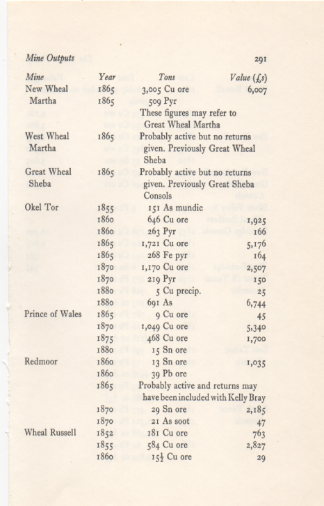
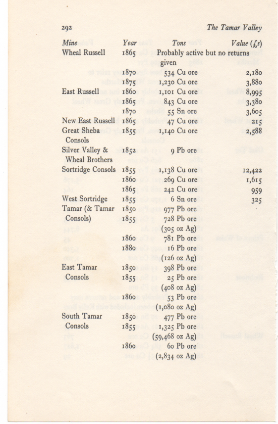
The Tamar Valley today is devoted to agriculture, but in the 1850s and 60s it rivalled West Cornwall in importance as a source of copper. For nearly thirty years after that it was the centre of arsenic production in the British Isles, and it had long been recognized as an important area of lead and silver mining. At a time when ships were changing from sail to steam, furnace-
All these industries—one employed over a thousand people while others were little more than family enterprises—grew up in an isolated countryside where people lived in close contact with their surroundings. Its compact and close-
Today Calstock has one of the highest unemployment rates in Devon and Cornwall; one quarry works where once there were ten. But between the 1860s and 80s a man living there could have been housed, clothed and shod with bricks, serge1 and leather produced within a mile of its quays. Paint coloured by ochre produced from
13
It is mentioned in the Welsh tale Culhwch and Olwen which may date from the 11th century.
The story describes the court as being at Celliwig in Cernyw (the Welsh name for Cornwall), otherwise known as the kingdom of Dumnonia including modern Devon.
The hall is guarded by Glewlwyd Gafaelfawr, Arthur's porter, and Culhwch has difficulty gaining entrance due to the special laws that restrict entry once a feast has begun.
Though there is no description of the place the implications of the story are of great wealth and splendour.
The story describes Arthur's warriors at the court in depth and says that: "From here, one of his Warband, Drem, could see a gnat as far away as Scotland; while another, Medyr, could shoot an arrow through the legs of a wren in Ireland!"
Some of the Trioedd Ynys Prydein (or Welsh Triads) mention Arthur and "Three Tribal Thrones of the Island of Britain" and locate one of his courts at Celliwig:
"Arthur as Chief Prince in Celliwig in Cernyw, and Bishop Bytwini as Chief Bishop, and Caradog Freichfras as Chief Elder."
Caradoc was his chief elder at this court and that Bishop Bytwini or Bedwin was chief bishop. This is one of the early triads found in Peniarth MS 54 reflecting information recorded before Geoffrey of Monmouth. The same triad goes on to say Arthur's other courts were at Mynyw and Pen Rhionydd. The triads also state that at Celliwig Mordred struck Gwenhwyfar a blow. This may have led to the Battle of Camlann. The early Welsh poem Pa gŵr yw'r porthor? may also Arthur is a mythic figure also suggest this court is entirely fictional. Given the name means "forest grove... it may have originally been envisaged as somewhere Otherworldly (sacred groves being common in Celtic myth) and only later might a specific location have been ascribed to it."mention the court.
Celliwig was also known to the Cornish as well, as it appears as Kyllywyc in the Cornish-
In the Iolo Manuscripts (1843), a corpus of pseudo-
Location
A 1302 Cornish legal record mentions a 'Thomas de Kellewik' from west Cornwall, though his exact place of origin is unknown.[3] Celliwig was identified by some Cornish antiquaries from 1816 onwards with Callington (occasionally locally attested as 'Callywith') where the ancient monuments of Castlewich Henge and Cadson Bury ringfort are in close proximity.
Their influence gave Callington its modern name in Common Cornish; Kelly Bray (Cornish:Kellibregh 'dappled grove') is located just to the north.
Another suggestion at the time was Kelliwith.[citation needed]
Other suggested locations include Gweek Wood[citation needed], and on the coast at Tintagel Barras Nose[citation needed] or Willapark. Rachel Bromwich, the latest editor of the Welsh Triads, matched it to Kelly Rounds, a hill fort in the Cornish parish of Egloshayle.
This had already been suggested by Charles Henderson in the Cornish Church Guide (1925) (p. 87).
Intriguingly, the Ravenna Cosmography identifies a major regional Roman-
Not far away from the modern Cornish border is the village of Kelly in Devon which takes it name from an ancient local family, attested as far back as the 11th century.
Outside Cornwall
However there are also a number of places called Cernyw or containing that name in Wales, e.g. the place name Coedkernew (Coed Cernyw) in Newport. So it has been suggested that this court might be the hillfort of Llanmelin, near Caerwent. As Caradog is connected to the Kingdom of Gwent this might support this idea. There is also a farm called Gelliweg on the Llŷn peninsula in Gwynedd which one pair of Arthurian researchers and writers, Steven Blake and Scott Lloyd, argue may be the location.[6]
Celliwic as a fictional place
Those who argue that
Bodmin Moor
by Gorlas. And this murdered King is by tradition also connected with another fortress roughly mid-
Castle Dore was called Carhurles meaning 'Gorlas's fortress'.
It therefore seems that the chieftain could have preceded King Mark of the Tristan saga at this earthwork which is known to have been re-
Assuming that the traditional link between the Arthurian and Tristan sagas could be factual and that King Mark DID succeed GORLAS and hold this southern territory by the sixth century, not only must Arthur's domain of Camlan, the oldest form of Camelot, and his stronghold Celliwic be sought elsewhere but the suggested area should be required to fulfil certain conditions in order to present itself a feasible proposition.
As Arthurian events would have taken place slightly before those of the Tristan saga, an Irish incursion should be in evidence for the saga's prologue depicts theCornish at loggerheads with Irish intruders; and a known Roman cavalry tradition is imperative if we are to believe that the proposed area could produce ahorse-
THE IRISH AND CARLYON
The place name Celliwic occurs not only in the Arthurian legend but also, as the variant Caellwig* in later Cornish history and is therefore certainly an area of the county and probably one of the Moorland. Although its site is in dispute, the signs are that It will eventually be permitted to settle where it already hovers between the hill forts of
96 35 32. 2
Killybury and Canyke-
too
Charters clearly demonstrate that the present misnomer Allen, by which the River Camel's tributary is known instead of by its correct name Laine, originally applied to the* Camel itself and was accurately rendered ALAN. As this River Alan or Camel twisted and turned, the Cornish epithet 'cam' meaning 'crooked' apparently prefixed not only the word 'heyle' meaning 'estuary' but also on occasion the name Alan. Thus, it would seem that the present name Camel is a corruption of one or both of the Cornish names for this river -
It might therefore be interesting to seek the required conditions in the Camel Valley. Of six known stones in Cornwall which are inscribed in the Irish script copipri-
An Irish incursion is certainly evident as is also a lingering Roman usage. Th© latter is hardly surprising in an area where Roman road stones at Boscastle and Tintagell and a 'camp of the legion' at Tregear have been found. Moreover, even AFTER the Roman cavalry station at Nanstallon meaning'Vale of Alan'was abandoned, it is apparent that agents of Rome used the most accessible route to and fromEngland across this north coast district at least as late as the fourth century when the Tintagel stone was inscribed. Ami, as some 300 years of contact with Roman custom appears to have influenced the local
Dumnonii so that they seemingly copied the Tregear shape when they built their earthwork at St. Kew, it might reasonably be expected that they would also emulate Roman strategy.
THE ISLE OF AVALLEN
Properly rendered, Avalon is the Celtic word 'avallen' meaning 'apple trees'. Incorporated in several place names, it is included in the name Worthyvale which appeared as 'Guerdevalen1 in the Domesday Book showing that there was an Early English homestead by an orchard adjacent to the area known as Slaughterbridge at the head of the River Camel. In fact, this very district has been traditionally regarded as the setting of the final act of the Arthurian drama.
Such regard, however, has lately been swamped in the scorn which has been poured upon the local name'Arthur's Grave1 for the Ogham stone actually commemorating 'Latinos', upon reports of battle debris found there, and upon the Tintagel paraphernalia so that the mere whisper of Arthur's name in this part of Cornwall seems actionable under the recent Retail Descriptions Act'. Yet, when it is noticed that Worthyvale is virtually an isle amid streamlets and that the word slaughter, probably deriving from the Old English for'muddy', suggests thesurrounding land wasonce mire, it is hard not to suspect that there IS Avalon.
It may seem immaterial that thewoods of Camlanand perhaps even Avaloncannot be seen for the trees of scepticism. However, the Camel Valley which has close on 900 yearsof popular and possibly justifiable identification with the Arthurian legend is largely dependent upon tourism. Surely time and money spent trying to prove Arthur elsewhere is notonly longoverdue, but might the more effectively be invested, in his traditional homeland where associations with him have yet to be CONVINCINGLY refuted'.
QUEST FOR SOULS
Time was when stories of Cornish saints were taken with the dose of salt reserved for thoseof the Arthurian and Tristan legends'. Not so now for the likelihood of essential events of both actually taking place is increasingly accepted. If the militancy of Christianity represented in the Arthurian and Tristan sagas very naturally predominated during the reassertion of Dumnonian tribalism after the Romans had gone, its civilising power was to settle it through the influence of saintly colonists-
Hitherto, the search for living spacehad motivated the movement of peoples, now it was the quest for souls and missionaries from Ireland, Wales and Brittany were to nurture the infant Christianity conceived here in Roman times. So many places on the map retain the names of these saints, the earliest of whom probably emanated from South) Wales where IItut had founded a monastic training school at LIantwit Ma jor in Glamorgan.
A reconstruction of possible events at Bodmin6could represent those in many a Cornish area during the fifth century. The Celts of Bodmin's hill fort, Castle Canyke, might have noticed the arrival of a stranger in the valley below them at the east end of the present Priory Park. Bearded and with the front of his head shaven leaving hair flowing long behind, the intruder would set about collecting stones and,wood which he would take to the spring. Soon he would build a hut, set up a roughly carved standing stone and surround these and his well with a piled-
Then he must have visited them, his psalm-
il
It is mentioned in the Welsh tale Culhwch and Olwen which may date from the 11th century.
The story describes the court as being at Celliwig (callington ) in Cernyw (the Welsh name for Cornwall),
otherwise known as the kingdom of Dumnonia including modern Devon.
The hall is guarded by Glewlwyd Gafaelfawr, Arthur's porter, and Culhwch has difficulty gaining entrance due to the special laws that restrict entry once a feast has begun.
Though there is no description of the place the implications of the story are of great wealth and splendour.
The story describes Arthur's warriors at the court in depth and says that: "From here, one of his Warband, Drem, could see a gnat as far away as Scotland; while another, Medyr, could shoot an arrow through the legs of a wren in Ireland!"
Some of the Trioedd Ynys Prydein (or Welsh Triads) mention Arthur and "Three Tribal Thrones of the Island of Britain" and locate one of his courts at Celliwig:
"Arthur as Chief Prince in Celliwig in Cernyw, and Bishop Bytwini as Chief Bishop, and Caradog Freichfras as Chief Elder."
Caradoc was his chief elder at this court and that Bishop Bytwini or Bedwin was chief bishop. This is one of the early triads found in Peniarth MS 54 reflecting information recorded before Geoffrey of Monmouth. The same triad goes on to say Arthur's other courts were at Mynyw and Pen Rhionydd. The triads also state that at Celliwig Mordred struck Gwenhwyfar a blow. This may have led to the Battle of Camlann.
The early Welsh poem Pagŵryw'r porthor? may also mention the court.
Celliwig was also known to the Cornish as well, as it appears as Kyllywyc in the Cornish-
In the Iolo Manuscripts (1843), a corpus of pseudo-
A 1302 Cornish legal record mentions a 'Thomas de Kellewik' from west Cornwall, though his exact place of origin is unknown.[3] Celliwig was identified by some Cornish antiquaries from 1816 onwards with Callington (occasionally locally attested as 'Callywith') where the ancient monuments of Castlewich Henge and Cadson Bury ringfort are in close proximity.
Their influence gave Callington its modern name in Common Cornish; Kelly Bray , Cornish : Kellibregh 'dappled grove' is located just to the north. Another suggestion at the time was Kelliwith.[citation needed] Other suggested locations include Gweek Wood[citation needed], and on the coast at Tintagel Barras Nose or Willapark. Rachel Bromwich, the latest editor of the Welsh Triads, matched it to Kelly Rounds, a hill fort in the Cornish parish of Egloshayle. This had already been suggested by Charles Henderson in the Cornish Church Guide (1925) (p. 87). Intriguingly, the Ravenna Cosmography identifies a major regional Roman-
However there are also a number of places called Cernyw or containing that name in Wales, e.g. the place name Coedkernew (Coed Cernyw) in Newport. So it has been suggested that this court might be the hillfort of Llanmelin, near Caerwent. As Caradog is connected to the Kingdom of Gwent this might support this idea. There is also a farm called Gelliweg on the Llŷn peninsula in Gwynedd which one pair of Arthurian researchers and writers, Steven Blake and Scott Lloyd, argue may be the location.[6]
Celliwic as a fictional place
Those who argue that Arthur is a mythic figure also suggest this court is entirely fictional. Given the name means "forest grove... it may have originally been envisaged as somewhere Otherworldly (sacred groves being common in Celtic myth) and only later might a specific location have been ascribed to it."[7
The Strange Dichotomy
Twisting and turning upon itself in great loops and bends, the river Tamar between Gunnislake and Plymouth flows through a hilly and tumbled valley rich in surprises. Half in Cornwall, half in Devon, its unusual and varied scenery is among the least known in the country and it hides relics of an industrial past hardly known outside Devon and Cornwall.
The Tamar Valley today is devoted to agriculture, but in the 1850s and 60s it rivalled West Cornwall in importance as a source of copper. For nearly thirty years after that it was the centre of arsenic production in the British Isles, and it had long been recognized as an important area of lead and silver mining. At a time when ships were changing from sail to steam, furnace-
All these industries—one employed over a thousand people while others were little more than family enterprises—grew up in an isolated countryside where people lived in close contact with their surroundings. Its compact and close-
Celliwig in Cernyw